Somvārpet geodata
Somvārpet (Karnataka) is a populated place; located in India in Asia/Kolkata (GMT+5.5) time zone. With population of 7,227 people, there are 3194 cities with bigger population in this country. Compared to other cities in India, 88.2% of cities are located further ↑North; 75.2% of cities are located further →East and 96.7% of cities have lower elevation than Somvārpet. Note1


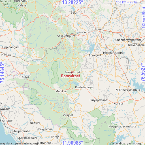
Somvārpet GPS coordinates[2]
12° 35' 49.128" North, 75° 50' 58.452" East
| Map corner | latitude | longitude |
|---|---|---|
| Upper-left | 13.28225°, | 75.14645° |
| Center: | 12.59698°, | 75.84957° |
| Lower-right: | 11.90988°, | 76.5527° |
| Map W x H: | 152.6×152.6 km | = 94.8×94.8mi |
| max Lat: | 34.9274° ⇑88.2% North |
| Somvārpet: | 12.59698° |
| min Lat: | ⇓11.8% South 8.09008° |
| min Long | Somvārpet | max Long |
| 68.82655° | 75.84957° | 96.81° |
| W 24.8%⇐ | ⇒75.2% E |
Elevation
Elevation of Somvārpet is 1133 m = 3717 ft, and this is 837.4 m = 2747 ft above average elevation for this country.
| Max E: |
3681 m = 12077 ft | 3.3% |
| Somvārpet | 1133 m 3717 ft | |
| Avg. | 295.6 m = 970 ft | |
Min E: |
1 m = 3 ft | 96.7% |
See also: India elevation on elevation.city.
Geographical zone
Somvārpet is located in North Torrid zone (between Equator and Tropic of Cancer). Distance of this Northern Tropic circle is 1205.3 km =748.9 mi to North.| Distance of | km | miles | from Somvārpet |
|---|---|---|---|
| North Pole | 8606.4 | 5347.8 | to North |
| Arctic Circle | 6000.5 | 3728.5 | to North |
| Tropic Cancer | 1205.3 | 748.9 | to North |
| Equator | 1400.7 | 870.4 | to South |


Nearby cities:
15 places around Somvārpet: (largest is in red/bold)
• Alūr
45.1 km =28 mi,  19°
19°
• Arkalgūd
29.3 km =18.2 mi,  51°
51°
• Gorūr
34.3 km =21.3 mi,  42°
42°
• Hole Narsipur
47.6 km =29.6 mi,  63°
63°
• Kodlipet
23 km =14.3 mi,  10°
10°
• Konanūr
22.1 km =13.7 mi,  80°
80°
• Kushālnagar
19.5 km =12.1 mi,  142°
142°
• Madikeri
22.5 km =14 mi,  212°
212°
• Piriyāpatna
39.9 km =24.8 mi, 136°
• Ponnampet
51.3 km =31.9 mi,  168°
168°
• Sakleshpur
38.9 km =24.2 mi,  349°
349°
• Sanivārsante
15.1 km =9.4 mi, 15°
• Sulya
50.3 km =31.3 mi,  265°
265°
• Suntikoppa
15.8 km =9.8 mi,  187°
187°
• Vīrarājendrapet
44.8 km =27.8 mi, 186°
Sources, notices
• [Note1] Compared only with cities in India existing in our database
• [Src1] Map data: © OpenStreetMap contributors (CC-BY-SA)
• [Src2] Other city data from geonames.org with taken over terms of usage.
• [Src3] Geographical zone / Annual Mean Temperature by Robert A. Rohde @ Wikipedia
