Banga geodata
Banga (Punjab) is a populated place; located in India in Asia/Kolkata (GMT+5.5) time zone. With population of 19,234 people, there are 2107 cities with bigger population in this country. Compared to other cities in India, 96.3% of cities are located further ↓South; 73.7% of cities are located further →East and 60.7% of cities have lower elevation than Banga. Note1


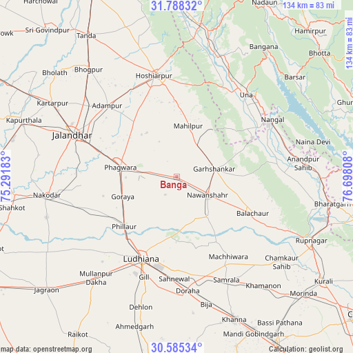
Banga GPS coordinates[2]
31° 11' 19.464" North, 75° 59' 41.82" East
| Map corner | latitude | longitude |
|---|---|---|
| Upper-left | 31.78832°, | 75.29183° |
| Center: | 31.18874°, | 75.99495° |
| Lower-right: | 30.58534°, | 76.69808° |
| Map W x H: | 133.8×133.8 km | = 83.1×83.1mi |
| max Lat: | 34.9274° ⇑3.7% North |
| Banga: | 31.18874° |
| min Lat: | ⇓96.3% South 8.09008° |
| min Long | Banga | max Long |
| 68.82655° | 75.99495° | 96.81° |
| W 26.3%⇐ | ⇒73.7% E |
Elevation
Elevation of Banga is 256 m = 840 ft, and this is 39.6 m = 130 ft below average elevation for this country.
| Max E: |
3681 m = 12077 ft | 39.3% |
| Avg. | 295.6 m = 970 ft | |
| Banga | 256 m = 840 ft | |
Min E: |
1 m = 3 ft | 60.7% |
See also: India elevation on elevation.city.
Geographical zone
Banga is located in North temperate zone (between Tropic of Cancer and the Arctic Circle). Distance of this Northern Tropic circle is 861.9 km =535.6 mi to South.| Distance of | km | miles | from Banga |
|---|---|---|---|
| North Pole | 6539.2 | 4063.3 | to North |
| Arctic Circle | 3933.3 | 2444 | to North |
| Tropic Cancer | 861.9 | 535.6 | to South |
| Equator | 3467.9 | 2154.9 | to South |


Nearby cities:
15 places around Banga: (largest is in red/bold)
• Adampur
38 km =23.6 mi,  315°
315°
• Bālāchor
32.5 km =20.2 mi,  116°
116°
• Garhshankar
14.2 km =8.8 mi,  78°
78°
• Hoshiārpur
39.5 km =24.5 mi,  348°
348°
• Jandiāla
36.1 km =22.4 mi,  264°
264°
• Ludhiāna
33.6 km =20.9 mi,  203°
203°
• Māchhīwāra
36.1 km =22.4 mi,  147°
147°
• Nawanshahr
13.6 km =8.5 mi, 121°
• Nūrmahal
39.5 km =24.5 mi,  254°
254°
• Phagwāra
21.4 km =13.3 mi,  280°
280°
• Phillaur
27.1 km =16.8 mi,  225°
225°
• Rāhon
19.2 km =11.9 mi,  141°
141°
• Santokhgarh
35.6 km =22.1 mi,  59°
59°
• Shām Churāsi
41.8 km =26 mi,  326°
326°
• Una
40.3 km =25 mi,  40°
40°
Sources, notices
• [Note1] Compared only with cities in India existing in our database
• [Src1] Map data: © OpenStreetMap contributors (CC-BY-SA)
• [Src2] Other city data from geonames.org with taken over terms of usage.
• [Src3] Geographical zone / Annual Mean Temperature by Robert A. Rohde @ Wikipedia
