Bariārpur geodata
Bariārpur (Bihar) is a populated place; located in India in Asia/Kolkata (GMT+5.5) time zone. With population of 14,595 people, there are 2503 cities with bigger population in this country. Compared to other cities in India, 65.1% of cities are located further ↓South; 88.4% of cities are located further ←West and 81.1% of cities have higher elevation than Bariārpur. Note1


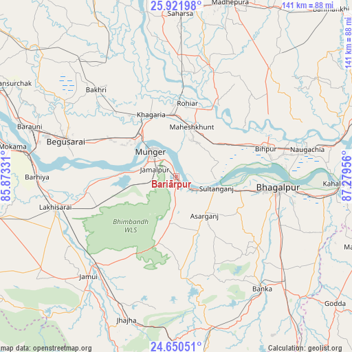
Bariārpur GPS coordinates[2]
25° 17' 16.476" North, 86° 34' 35.148" East
| Map corner | latitude | longitude |
|---|---|---|
| Upper-left | 25.92198°, | 85.87331° |
| Center: | 25.28791°, | 86.57643° |
| Lower-right: | 24.65051°, | 87.27956° |
| Map W x H: | 141.4×141.4 km | = 87.9×87.9mi |
| max Lat: | 34.9274° ⇑34.9% North |
| Bariārpur: | 25.28791° |
| min Lat: | ⇓65.1% South 8.09008° |
| min Long | Bariārpur | max Long |
| 68.82655° | 86.57643° | 96.81° |
| W 88.4%⇐ | ⇒11.6% E |
Elevation
Elevation of Bariārpur is 44 m = 144 ft, and this is 251.6 m = 825 ft below average elevation for this country.
| Max E: |
3681 m = 12077 ft | 81.1% |
| Avg. | 295.6 m = 970 ft | |
| Bariārpur | 44 m = 144 ft | |
Min E: |
1 m = 3 ft | 18.9% |
See also: India elevation on elevation.city.
Geographical zone
Bariārpur is located in North temperate zone (between Tropic of Cancer and the Arctic Circle). Distance of this Northern Tropic circle is 205.8 km =127.9 mi to South.| Distance of | km | miles | from Bariārpur |
|---|---|---|---|
| North Pole | 7195.3 | 4471 | to North |
| Arctic Circle | 4589.4 | 2851.7 | to North |
| Tropic Cancer | 205.8 | 127.9 | to South |
| Equator | 2811.8 | 1747.2 | to South |


Nearby cities:
15 places around Bariārpur: (largest is in red/bold)
• Amarpur
42.9 km =26.7 mi,  130°
130°
• Asarganj
18.9 km =11.7 mi,  144°
144°
• Barhiya
55.9 km =34.7 mi,  270°
270°
• Begusarai
46.8 km =29.1 mi,  288°
288°
• Bhāgalpur
40.1 km =24.9 mi,  96°
96°
• Bānka
57.1 km =35.5 mi, 142°
• Ghoga
58.9 km =36.6 mi, 97°
• Jamālpur
9.2 km =5.7 mi, 287°
• Jamūī
53.6 km =33.3 mi,  221°
221°
• Jhā-Jhā
60.8 km =37.8 mi,  199°
199°
• Khagaria
26.2 km =16.3 mi,  335°
335°
• Kharagpur
18.3 km =11.4 mi,  186°
186°
• Luckeesarai
50 km =31.1 mi,  255°
255°
• Monghyr
14.1 km =8.8 mi,  313°
313°
• Naugachhia
53.7 km =33.4 mi,  78°
78°
Sources, notices
• [Note1] Compared only with cities in India existing in our database
• [Src1] Map data: © OpenStreetMap contributors (CC-BY-SA)
• [Src2] Other city data from geonames.org with taken over terms of usage.
• [Src3] Geographical zone / Annual Mean Temperature by Robert A. Rohde @ Wikipedia
