Jamālpur geodata
Jamālpur (Bihar) is a populated place; located in India in Asia/Kolkata (GMT+5.5) time zone. With population of 100,780 people, there are 435 cities with bigger population in this country. Compared to other cities in India, 65.3% of cities are located further ↓South; 88.2% of cities are located further ←West and 78.9% of cities have higher elevation than Jamālpur. Note1


Jamālpur GPS coordinates[2]
25° 18' 45.288" North, 86° 29' 19.968" East
| Map corner | latitude | longitude |
|---|---|---|
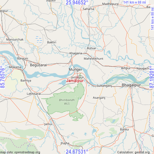
| Upper-left | 25.94652°, | 85.78576° |
| Center: | 25.31258°, | 86.48888° |
| Lower-right: | 24.67531°, | 87.19201° |
| Map W x H: | 141.3×141.3 km | = 87.8×87.8mi |
| max Lat: | 34.9274° ⇑34.7% North |
| Jamālpur: | 25.31258° |
| min Lat: | ⇓65.3% South 8.09008° |
| min Long | Jamālpur | max Long |
| 68.82655° | 86.48888° | 96.81° |
| W 88.2%⇐ | ⇒11.8% E |
Elevation
Elevation of Jamālpur is 52 m = 171 ft, and this is 243.6 m = 799 ft below average elevation for this country.
| Max E: |
3681 m = 12077 ft | 78.9% |
| Avg. | 295.6 m = 970 ft | |
| Jamālpur | 52 m = 171 ft | |
Min E: |
1 m = 3 ft | 21.1% |
See also: Jamālpur elevation on elevation.city.
Geographical zone
Jamālpur is located in North temperate zone (between Tropic of Cancer and the Arctic Circle). Distance of this Northern Tropic circle is 208.6 km =129.6 mi to South.| Distance of | km | miles | from Jamālpur |
|---|---|---|---|
| North Pole | 7192.6 | 4469.3 | to North |
| Arctic Circle | 4586.7 | 2850 | to North |
| Tropic Cancer | 208.6 | 129.6 | to South |
| Equator | 2814.5 | 1748.8 | to South |


Nearby cities:
15 places around Jamālpur: (largest is in red/bold)
• Amarpur
51.5 km =32 mi,  126°
126°
• Asarganj
26.8 km =16.7 mi, 132°
• Barhiya
47.2 km =29.3 mi,  266°
266°
• Bariārpur
9.2 km =5.7 mi,  107°
107°
• Begusarai
37.6 km =23.4 mi,  288°
288°
• Bhāgalpur
49.1 km =30.5 mi,  98°
98°
• Bāruni
55.3 km =34.4 mi, 289°
• Jamūī
50.5 km =31.4 mi,  211°
211°
• Jhā-Jhā
61.2 km =38 mi,  190°
190°
• Khagaria
21.2 km =13.2 mi,  354°
354°
• Kharagpur
22 km =13.7 mi,  162°
162°
• Luckeesarai
42.4 km =26.3 mi,  249°
249°
• Mokameh
57.7 km =35.9 mi,  279°
279°
• Monghyr
7 km =4.3 mi, 348°
• Teghra
58.6 km =36.4 mi, 289°
Sources, notices
• [Note1] Compared only with cities in India existing in our database
• [Src1] Map data: © OpenStreetMap contributors (CC-BY-SA)
• [Src2] Other city data from geonames.org with taken over terms of usage.
• [Src3] Geographical zone / Annual Mean Temperature by Robert A. Rohde @ Wikipedia
