Monghyr geodata
Monghyr (Bihar) is a populated place; located in India in Asia/Kolkata (GMT+5.5) time zone. With population of 203,163 people, there are 206 cities with bigger population in this country. Compared to other cities in India, 65.8% of cities are located further ↓South; 88.1% of cities are located further ←West and 79.7% of cities have higher elevation than Monghyr. Note1


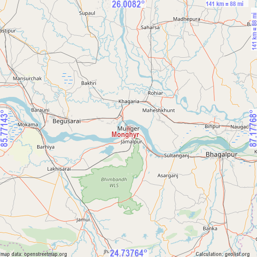
Monghyr GPS coordinates[2]
25° 22' 28.524" North, 86° 28' 28.38" East
| Map corner | latitude | longitude |
|---|---|---|
| Upper-left | 26.0082°, | 85.77143° |
| Center: | 25.37459°, | 86.47455° |
| Lower-right: | 24.73764°, | 87.17768° |
| Map W x H: | 141.3×141.3 km | = 87.8×87.8mi |
| max Lat: | 34.9274° ⇑34.2% North |
| Monghyr: | 25.37459° |
| min Lat: | ⇓65.8% South 8.09008° |
| min Long | Monghyr | max Long |
| 68.82655° | 86.47455° | 96.81° |
| W 88.1%⇐ | ⇒11.9% E |
Elevation
Elevation of Monghyr is 49 m = 161 ft, and this is 246.6 m = 809 ft below average elevation for this country.
| Max E: |
3681 m = 12077 ft | 79.7% |
| Avg. | 295.6 m = 970 ft | |
| Monghyr | 49 m = 161 ft | |
Min E: |
1 m = 3 ft | 20.3% |
See also: Monghyr elevation on elevation.city.
Geographical zone
Monghyr is located in North temperate zone (between Tropic of Cancer and the Arctic Circle). Distance of this Northern Tropic circle is 215.5 km =133.9 mi to South.| Distance of | km | miles | from Monghyr |
|---|---|---|---|
| North Pole | 7185.7 | 4465 | to North |
| Arctic Circle | 4579.8 | 2845.8 | to North |
| Tropic Cancer | 215.5 | 133.9 | to South |
| Equator | 2821.4 | 1753.1 | to South |


Nearby cities:
15 places around Monghyr: (largest is in red/bold)
• Amarpur
56.9 km =35.4 mi,  130°
130°
• Asarganj
32.8 km =20.4 mi,  139°
139°
• Bangaon
54.9 km =34.1 mi,  3°
3°
• Barhiya
46.6 km =29 mi,  258°
258°
• Bariārpur
14.1 km =8.8 mi, 133°
• Begusarai
34.6 km =21.5 mi,  278°
278°
• Bhāgalpur
52 km =32.3 mi,  106°
106°
• Bāruni
52.1 km =32.4 mi, 282°
• Jamālpur
7 km =4.3 mi,  168°
168°
• Jamūī
55.8 km =34.7 mi,  206°
206°
• Khagaria
14.2 km =8.8 mi,  356°
356°
• Kharagpur
29 km =18 mi,  163°
163°
• Luckeesarai
44.1 km =27.4 mi,  240°
240°
• Mokameh
55.6 km =34.5 mi,  272°
272°
• Teghra
55.2 km =34.3 mi, 283°
Sources, notices
• [Note1] Compared only with cities in India existing in our database
• [Src1] Map data: © OpenStreetMap contributors (CC-BY-SA)
• [Src2] Other city data from geonames.org with taken over terms of usage.
• [Src3] Geographical zone / Annual Mean Temperature by Robert A. Rohde @ Wikipedia
