Chamba geodata
Chamba (Himachal Pradesh) is a populated place; located in India in Asia/Kolkata (GMT+5.5) time zone. With population of 21,502 people, there are 1935 cities with bigger population in this country. Compared to other cities in India, 98.5% of cities are located further ↓South; 72.3% of cities are located further →East and 95.8% of cities have lower elevation than Chamba. Note1


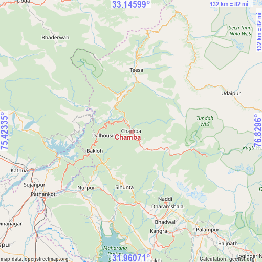
Chamba GPS coordinates[2]
32° 33' 19.116" North, 76° 7' 35.292" East
| Map corner | latitude | longitude |
|---|---|---|
| Upper-left | 33.14599°, | 75.42335° |
| Center: | 32.55531°, | 76.12647° |
| Lower-right: | 31.96071°, | 76.8296° |
| Map W x H: | 131.8×131.8 km | = 81.9×81.9mi |
| max Lat: | 34.9274° ⇑1.5% North |
| Chamba: | 32.55531° |
| min Lat: | ⇓98.5% South 8.09008° |
| min Long | Chamba | max Long |
| 68.82655° | 76.12647° | 96.81° |
| W 27.7%⇐ | ⇒72.3% E |
Elevation
Elevation of Chamba is 951 m = 3120 ft, and this is 655.4 m = 2150 ft above average elevation for this country.
| Max E: |
3681 m = 12077 ft | 4.2% |
| Chamba | 951 m 3120 ft | |
| Avg. | 295.6 m = 970 ft | |
Min E: |
1 m = 3 ft | 95.8% |
See also: India elevation on elevation.city.
Geographical zone
Chamba is located in North temperate zone (between Tropic of Cancer and the Arctic Circle). Distance of this Northern Tropic circle is 1013.9 km =630 mi to South.| Distance of | km | miles | from Chamba |
|---|---|---|---|
| North Pole | 6387.3 | 3968.9 | to North |
| Arctic Circle | 3781.4 | 2349.7 | to North |
| Tropic Cancer | 1013.9 | 630 | to South |
| Equator | 3619.8 | 2249.2 | to South |


Nearby cities:
15 places around Chamba: (largest is in red/bold)
• Bakloh
21.2 km =13.2 mi,  246°
246°
• Bhadarwāh
60.7 km =37.7 mi,  320°
320°
• Chowari
17.4 km =10.8 mi,  218°
218°
• Chuāri Khās
17.4 km =10.8 mi, 217°
• Dalhousie
16.9 km =10.5 mi,  268°
268°
• Daulatpur
56.9 km =35.4 mi,  167°
167°
• Dharamsala
41.5 km =25.8 mi,  153°
153°
• Kathua
60.1 km =37.3 mi, 249°
• Kotla
35.1 km =21.8 mi,  194°
194°
• Kāngar
53.2 km =33.1 mi, 166°
• Nagrota
55.5 km =34.5 mi,  183°
183°
• Parol
69 km =42.9 mi, 250°
• Pathānkot
54.3 km =33.7 mi,  234°
234°
• Pālampur
63.5 km =39.5 mi,  140°
140°
• Yol
44 km =27.3 mi, 171°
Sources, notices
• [Note1] Compared only with cities in India existing in our database
• [Src1] Map data: © OpenStreetMap contributors (CC-BY-SA)
• [Src2] Other city data from geonames.org with taken over terms of usage.
• [Src3] Geographical zone / Annual Mean Temperature by Robert A. Rohde @ Wikipedia
