Chowari geodata
Chowari (Himachal Pradesh) is a populated place; located in India in Asia/Kolkata (GMT+5.5) time zone. With population of 3,000 people, there are 3412 cities with bigger population in this country. Compared to other cities in India, 98.4% of cities are located further ↓South; 73.5% of cities are located further →East and 96.3% of cities have lower elevation than Chowari. Note1


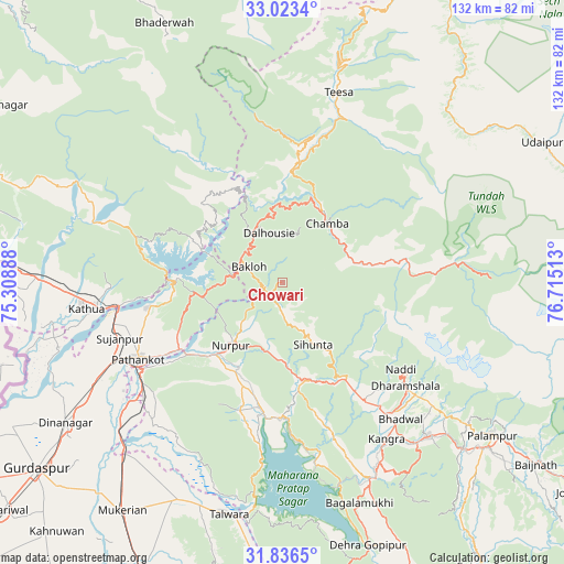
Chowari GPS coordinates[2]
32° 25' 54.84" North, 76° 0' 43.2" East
| Map corner | latitude | longitude |
|---|---|---|
| Upper-left | 33.0234°, | 75.30888° |
| Center: | 32.4319°, | 76.012° |
| Lower-right: | 31.8365°, | 76.71513° |
| Map W x H: | 132×132 km | = 82×82mi |
| max Lat: | 34.9274° ⇑1.6% North |
| Chowari: | 32.4319° |
| min Lat: | ⇓98.4% South 8.09008° |
| min Long | Chowari | max Long |
| 68.82655° | 76.012° | 96.81° |
| W 26.5%⇐ | ⇒73.5% E |
Elevation
Elevation of Chowari is 1025 m = 3363 ft, and this is 729.4 m = 2393 ft above average elevation for this country.
| Max E: |
3681 m = 12077 ft | 3.7% |
| Chowari | 1025 m 3363 ft | |
| Avg. | 295.6 m = 970 ft | |
Min E: |
1 m = 3 ft | 96.3% |
See also: India elevation on elevation.city.
Geographical zone
Chowari is located in North temperate zone (between Tropic of Cancer and the Arctic Circle). Distance of this Northern Tropic circle is 1000.2 km =621.5 mi to South.| Distance of | km | miles | from Chowari |
|---|---|---|---|
| North Pole | 6401 | 3977.4 | to North |
| Arctic Circle | 3795.1 | 2358.2 | to North |
| Tropic Cancer | 1000.2 | 621.5 | to South |
| Equator | 3606.1 | 2240.7 | to South |


Nearby cities:
15 places around Chowari: (largest is in red/bold)
• Bakloh
10.2 km =6.3 mi,  301°
301°
• Chamba
17.4 km =10.8 mi,  38°
38°
• Chuāri Khās
0.3 km =0.2 mi,  124°
124°
• Dalhousie
14.7 km =9.1 mi,  335°
335°
• Daulatpur
47.9 km =29.8 mi,  150°
150°
• Dharamsala
37.3 km =23.2 mi,  129°
129°
• Hājipur
56.1 km =34.9 mi,  205°
205°
• Kathua
46.2 km =28.7 mi,  261°
261°
• Kotla
20.3 km =12.6 mi,  174°
174°
• Kāngar
44.6 km =27.7 mi, 148°
• Nagrota
42.3 km =26.3 mi, 169°
• Parol
55.1 km =34.2 mi, 260°
• Pathānkot
38 km =23.6 mi,  242°
242°
• Talwāra
56.2 km =34.9 mi,  192°
192°
• Yol
34.4 km =21.4 mi, 149°
Sources, notices
• [Note1] Compared only with cities in India existing in our database
• [Src1] Map data: © OpenStreetMap contributors (CC-BY-SA)
• [Src2] Other city data from geonames.org with taken over terms of usage.
• [Src3] Geographical zone / Annual Mean Temperature by Robert A. Rohde @ Wikipedia
