Chuāri Khās geodata
Chuāri Khās (Himachal Pradesh) is a populated place; located in India in Asia/Kolkata (GMT+5.5) time zone. With population of 3,430 people, there are 3396 cities with bigger population in this country. Compared to other cities in India, 98.4% of cities are located further ↓South; 73.5% of cities are located further →East and 96.3% of cities have lower elevation than Chuāri Khās. Note1


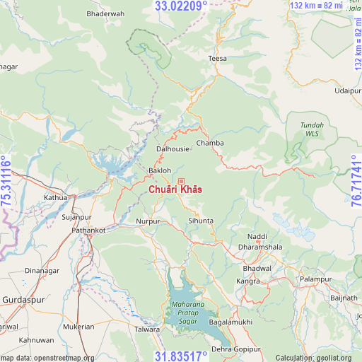
Chuāri Khās GPS coordinates[2]
32° 25' 50.088" North, 76° 0' 51.408" East
| Map corner | latitude | longitude |
|---|---|---|
| Upper-left | 33.02209°, | 75.31116° |
| Center: | 32.43058°, | 76.01428° |
| Lower-right: | 31.83517°, | 76.71741° |
| Map W x H: | 132×132 km | = 82×82mi |
| max Lat: | 34.9274° ⇑1.6% North |
| Chuāri Khās: | 32.43058° |
| min Lat: | ⇓98.4% South 8.09008° |
| min Long | Chuāri Khās | max Long |
| 68.82655° | 76.01428° | 96.81° |
| W 26.5%⇐ | ⇒73.5% E |
Elevation
Elevation of Chuāri Khās is 1040 m = 3412 ft, and this is 744.4 m = 2442 ft above average elevation for this country.
| Max E: |
3681 m = 12077 ft | 3.7% |
| Chuāri Khās | 1040 m 3412 ft | |
| Avg. | 295.6 m = 970 ft | |
Min E: |
1 m = 3 ft | 96.3% |
See also: India elevation on elevation.city.
Geographical zone
Chuāri Khās is located in North temperate zone (between Tropic of Cancer and the Arctic Circle). Distance of this Northern Tropic circle is 1000 km =621.4 mi to South.| Distance of | km | miles | from Chuāri Khās |
|---|---|---|---|
| North Pole | 6401.1 | 3977.5 | to North |
| Arctic Circle | 3795.2 | 2358.2 | to North |
| Tropic Cancer | 1000 | 621.4 | to South |
| Equator | 3605.9 | 2240.6 | to South |


Nearby cities:
15 places around Chuāri Khās: (largest is in red/bold)
• Bakloh
10.5 km =6.5 mi,  301°
301°
• Chamba
17.4 km =10.8 mi,  37°
37°
• Chowari
0.3 km =0.2 mi, 304°
• Dalhousie
14.9 km =9.3 mi,  334°
334°
• Daulatpur
47.7 km =29.6 mi,  150°
150°
• Dharamsala
37.1 km =23.1 mi,  129°
129°
• Hājipur
56 km =34.8 mi,  205°
205°
• Kathua
46.4 km =28.8 mi,  261°
261°
• Kotla
20.2 km =12.6 mi,  174°
174°
• Kāngar
44.4 km =27.6 mi, 148°
• Nagrota
42.2 km =26.2 mi, 170°
• Parol
55.3 km =34.4 mi, 260°
• Pathānkot
38.1 km =23.7 mi,  242°
242°
• Talwāra
56.1 km =34.9 mi,  192°
192°
• Yol
34.2 km =21.3 mi, 149°
Sources, notices
• [Note1] Compared only with cities in India existing in our database
• [Src1] Map data: © OpenStreetMap contributors (CC-BY-SA)
• [Src2] Other city data from geonames.org with taken over terms of usage.
• [Src3] Geographical zone / Annual Mean Temperature by Robert A. Rohde @ Wikipedia
