Panna geodata
Panna (Madhya Pradesh) is a populated place; located in India in Asia/Kolkata (GMT+5.5) time zone. With population of 46,791 people, there are 944 cities with bigger population in this country. Compared to other cities in India, 61.9% of cities are located further ↓South; 69.4% of cities are located further ←West and 76.4% of cities have lower elevation than Panna. Note1


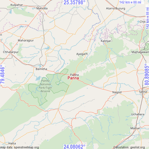
Panna GPS coordinates[2]
24° 43' 15.384" North, 80° 11' 15.792" East
| Map corner | latitude | longitude |
|---|---|---|
| Upper-left | 25.35798°, | 79.4846° |
| Center: | 24.72094°, | 80.18772° |
| Lower-right: | 24.08062°, | 80.89085° |
| Map W x H: | 142×142 km | = 88.2×88.2mi |
| max Lat: | 34.9274° ⇑38.1% North |
| Panna: | 24.72094° |
| min Lat: | ⇓61.9% South 8.09008° |
| min Long | Panna | max Long |
| 68.82655° | 80.18772° | 96.81° |
| W 69.4%⇐ | ⇒30.6% E |
Elevation
Elevation of Panna is 404 m = 1325 ft, and this is 108.4 m = 356 ft above average elevation for this country.
| Max E: |
3681 m = 12077 ft | 23.6% |
| Panna | 404 m 1325 ft | |
| Avg. | 295.6 m = 970 ft | |
Min E: |
1 m = 3 ft | 76.4% |
See also: Panna elevation on elevation.city.
Geographical zone
Panna is located in North temperate zone (between Tropic of Cancer and the Arctic Circle). Distance of this Northern Tropic circle is 142.8 km =88.7 mi to South.| Distance of | km | miles | from Panna |
|---|---|---|---|
| North Pole | 7258.4 | 4510.2 | to North |
| Arctic Circle | 4652.5 | 2890.9 | to North |
| Tropic Cancer | 142.8 | 88.7 | to South |
| Equator | 2748.7 | 1708 | to South |


Nearby cities:
15 places around Panna: (largest is in red/bold)
• Ajaigarh
21.1 km =13.1 mi,  20°
20°
• Amānganj
36.1 km =22.4 mi,  205°
205°
• Atarra
73.8 km =45.9 mi,  31°
31°
• Bijāwar
71.3 km =44.3 mi,  261°
261°
• Chandla
39 km =24.2 mi,  0°
0°
• Chhatarpur
64.3 km =40 mi,  289°
289°
• Khajuraho Group of Monuments
29.3 km =18.2 mi,  298°
298°
• Kothi
59.7 km =37.1 mi,  86°
86°
• Madhogarh
75.2 km =46.7 mi,  103°
103°
• Mahobā
70.7 km =43.9 mi,  333°
333°
• Naraini
59.7 km =37.1 mi, 29°
• Nāgod
43.8 km =27.2 mi,  112°
112°
• Pawai
50.6 km =31.4 mi,  182°
182°
• Rājnagar
33.6 km =20.9 mi, 303°
• Satna
66.6 km =41.4 mi, 103°
Sources, notices
• [Note1] Compared only with cities in India existing in our database
• [Src1] Map data: © OpenStreetMap contributors (CC-BY-SA)
• [Src2] Other city data from geonames.org with taken over terms of usage.
• [Src3] Geographical zone / Annual Mean Temperature by Robert A. Rohde @ Wikipedia
