Ajaigarh geodata
Ajaigarh (Madhya Pradesh) is a populated place; located in India in Asia/Kolkata (GMT+5.5) time zone. With population of 14,640 people, there are 2498 cities with bigger population in this country. Compared to other cities in India, 63% of cities are located further ↓South; 70% of cities are located further ←West and 54.2% of cities have lower elevation than Ajaigarh. Note1


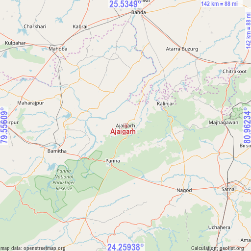
Ajaigarh GPS coordinates[2]
24° 53' 55.644" North, 80° 15' 33.156" East
| Map corner | latitude | longitude |
|---|---|---|
| Upper-left | 25.5349°, | 79.55609° |
| Center: | 24.89879°, | 80.25921° |
| Lower-right: | 24.25938°, | 80.96234° |
| Map W x H: | 141.8×141.8 km | = 88.1×88.1mi |
| max Lat: | 34.9274° ⇑37% North |
| Ajaigarh: | 24.89879° |
| min Lat: | ⇓63% South 8.09008° |
| min Long | Ajaigarh | max Long |
| 68.82655° | 80.25921° | 96.81° |
| W 70%⇐ | ⇒30% E |
Elevation
Elevation of Ajaigarh is 223 m = 732 ft, and this is 72.6 m = 238 ft below average elevation for this country.
| Max E: |
3681 m = 12077 ft | 45.8% |
| Avg. | 295.6 m = 970 ft | |
| Ajaigarh | 223 m = 732 ft | |
Min E: |
1 m = 3 ft | 54.2% |
See also: India elevation on elevation.city.
Geographical zone
Ajaigarh is located in North temperate zone (between Tropic of Cancer and the Arctic Circle). Distance of this Northern Tropic circle is 162.6 km =101 mi to South.| Distance of | km | miles | from Ajaigarh |
|---|---|---|---|
| North Pole | 7238.6 | 4497.9 | to North |
| Arctic Circle | 4632.7 | 2878.6 | to North |
| Tropic Cancer | 162.6 | 101 | to South |
| Equator | 2768.5 | 1720.3 | to South |


Nearby cities:
15 places around Ajaigarh: (largest is in red/bold)
• Amānganj
57.1 km =35.5 mi,  203°
203°
• Atarra
53.3 km =33.1 mi,  36°
36°
• Bisenda Buzurg
66.8 km =41.5 mi,  32°
32°
• Bānda
64.8 km =40.3 mi,  6°
6°
• Chandla
20.3 km =12.6 mi,  340°
340°
• Kabrāi
61.8 km =38.4 mi, 335°
• Khajuraho Group of Monuments
33.3 km =20.7 mi,  260°
260°
• Kothi
54.8 km =34.1 mi,  107°
107°
• Mahobā
58.2 km =36.2 mi,  318°
318°
• Mataundh
60.6 km =37.7 mi,  350°
350°
• Naraini
39 km =24.2 mi, 33°
• Nāgod
49.5 km =30.8 mi,  137°
137°
• Panna
21.1 km =13.1 mi, 200°
• Rājnagar
35.1 km =21.8 mi,  268°
268°
• Satna
67.6 km =42 mi,  121°
121°
Sources, notices
• [Note1] Compared only with cities in India existing in our database
• [Src1] Map data: © OpenStreetMap contributors (CC-BY-SA)
• [Src2] Other city data from geonames.org with taken over terms of usage.
• [Src3] Geographical zone / Annual Mean Temperature by Robert A. Rohde @ Wikipedia
