Gajendragarh geodata
Gajendragarh (Karnataka) is a populated place; located in India in Asia/Kolkata (GMT+5.5) time zone. With population of 29,749 people, there are 1457 cities with bigger population in this country. Compared to other cities in India, 78.8% of cities are located further ↑North; 73.9% of cities are located further →East and 90.3% of cities have lower elevation than Gajendragarh. Note1


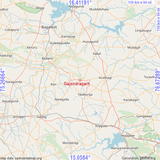
Gajendragarh GPS coordinates[2]
15° 44' 10.608" North, 75° 58' 11.136" East
| Map corner | latitude | longitude |
|---|---|---|
| Upper-left | 16.41191°, | 75.26664° |
| Center: | 15.73628°, | 75.96976° |
| Lower-right: | 15.0584°, | 76.67289° |
| Map W x H: | 150.5×150.5 km | = 93.5×93.5mi |
| max Lat: | 34.9274° ⇑78.8% North |
| Gajendragarh: | 15.73628° |
| min Lat: | ⇓21.2% South 8.09008° |
| min Long | Gajendragarh | max Long |
| 68.82655° | 75.96976° | 96.81° |
| W 26.1%⇐ | ⇒73.9% E |
Elevation
Elevation of Gajendragarh is 643 m = 2110 ft, and this is 347.4 m = 1140 ft above average elevation for this country.
| Max E: |
3681 m = 12077 ft | 9.7% |
| Gajendragarh | 643 m 2110 ft | |
| Avg. | 295.6 m = 970 ft | |
Min E: |
1 m = 3 ft | 90.3% |
See also: India elevation on elevation.city.
Geographical zone
Gajendragarh is located in North Torrid zone (between Equator and Tropic of Cancer). Distance of this Northern Tropic circle is 856.2 km =532 mi to North.| Distance of | km | miles | from Gajendragarh |
|---|---|---|---|
| North Pole | 8257.4 | 5130.9 | to North |
| Arctic Circle | 5651.5 | 3511.7 | to North |
| Tropic Cancer | 856.2 | 532 | to North |
| Equator | 1749.7 | 1087.2 | to South |


Nearby cities:
15 places around Gajendragarh: (largest is in red/bold)
• Bagalkot
58 km =36 mi,  329°
329°
• Bādāmi
37.1 km =23.1 mi,  302°
302°
• Gadag
49.9 km =31 mi,  226°
226°
• Gadag-Betageri
51.9 km =32.2 mi, 226°
• Guledagudda
39.9 km =24.8 mi, 331°
• Hungund
37.5 km =23.3 mi,  14°
14°
• Ilkal
29.2 km =18.1 mi,  31°
31°
• Kavalūr
49.9 km =31 mi,  183°
183°
• Kerūr
54.8 km =34.1 mi, 304°
• Koppal
47.8 km =29.7 mi,  155°
155°
• Kushtagi
23.8 km =14.8 mi,  84°
84°
• Mudgal
59.1 km =36.7 mi,  58°
58°
• Naregal
25.1 km =15.6 mi,  223°
223°
• Ron
25.6 km =15.9 mi,  260°
260°
• Yelbarga
14.2 km =8.8 mi, 161°
Sources, notices
• [Note1] Compared only with cities in India existing in our database
• [Src1] Map data: © OpenStreetMap contributors (CC-BY-SA)
• [Src2] Other city data from geonames.org with taken over terms of usage.
• [Src3] Geographical zone / Annual Mean Temperature by Robert A. Rohde @ Wikipedia
