Morwa geodata
Morwa (Gujarat) is a populated place; located in India in Asia/Kolkata (GMT+5.5) time zone. With population of 20,168 people, there are 2025 cities with bigger population in this country. Compared to other cities in India, 50.9% of cities are located further ↓South; 90.9% of cities are located further →East and 57.7% of cities have higher elevation than Morwa. Note1


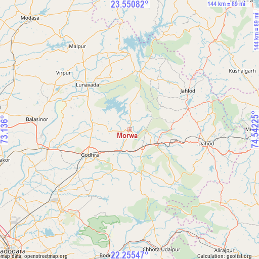
Morwa GPS coordinates[2]
22° 54' 16.884" North, 73° 50' 20.832" East
| Map corner | latitude | longitude |
|---|---|---|
| Upper-left | 23.55082°, | 73.136° |
| Center: | 22.90469°, | 73.83912° |
| Lower-right: | 22.25547°, | 74.54225° |
| Map W x H: | 144×144 km | = 89.5×89.5mi |
| max Lat: | 34.9274° ⇑49.1% North |
| Morwa: | 22.90469° |
| min Lat: | ⇓50.9% South 8.09008° |
| min Long | Morwa | max Long |
| 68.82655° | 73.83912° | 96.81° |
| W 9.1%⇐ | ⇒90.9% E |
Elevation
Elevation of Morwa is 159 m = 522 ft, and this is 136.6 m = 448 ft below average elevation for this country.
| Max E: |
3681 m = 12077 ft | 57.7% |
| Avg. | 295.6 m = 970 ft | |
| Morwa | 159 m = 522 ft | |
Min E: |
1 m = 3 ft | 42.3% |
See also: India elevation on elevation.city.
Geographical zone
Morwa is located in North Torrid zone (between Equator and Tropic of Cancer). Distance of this Northern Tropic circle is 59.2 km =36.8 mi to North.| Distance of | km | miles | from Morwa |
|---|---|---|---|
| North Pole | 7460.3 | 4635.6 | to North |
| Arctic Circle | 4854.4 | 3016.4 | to North |
| Tropic Cancer | 59.2 | 36.8 | to North |
| Equator | 2546.8 | 1582.5 | to South |


Nearby cities:
15 places around Morwa: (largest is in red/bold)
• Bhābhra
65.2 km =40.5 mi,  129°
129°
• Chhota Udepur
69.2 km =43 mi,  164°
164°
• Devgadh Bāriya
23.3 km =14.5 mi, 162°
• Dohad
43.8 km =27.2 mi,  100°
100°
• Godhra
27.1 km =16.8 mi,  237°
237°
• Hālol
58.4 km =36.3 mi,  220°
220°
• Jetpur
62.3 km =38.7 mi,  179°
179°
• Kushālgarh
70.6 km =43.9 mi,  62°
62°
• Kālol
50.8 km =31.6 mi,  229°
229°
• Lūnāvāda
34.2 km =21.3 mi,  316°
316°
• Mālpur
63.4 km =39.4 mi, 323°
• Shivrājpur
58.5 km =36.4 mi,  203°
203°
• Thāsra
65.4 km =40.6 mi,  259°
259°
• Vejalpur
37 km =23 mi, 229°
• Virpur
48.5 km =30.1 mi,  310°
310°
Sources, notices
• [Note1] Compared only with cities in India existing in our database
• [Src1] Map data: © OpenStreetMap contributors (CC-BY-SA)
• [Src2] Other city data from geonames.org with taken over terms of usage.
• [Src3] Geographical zone / Annual Mean Temperature by Robert A. Rohde @ Wikipedia
