Chittaurgarh geodata
Chittaurgarh (Rajasthan) is a populated place; located in India in Asia/Kolkata (GMT+5.5) time zone. With population of 106,710 people, there are 412 cities with bigger population in this country. Compared to other cities in India, 62.9% of cities are located further ↓South; 85.8% of cities are located further →East and 76.4% of cities have lower elevation than Chittaurgarh. Note1


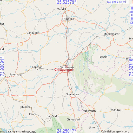
Chittaurgarh GPS coordinates[2]
24° 53' 22.668" North, 74° 37' 26.508" East
| Map corner | latitude | longitude |
|---|---|---|
| Upper-left | 25.52579°, | 73.92091° |
| Center: | 24.88963°, | 74.62403° |
| Lower-right: | 24.25017°, | 75.32716° |
| Map W x H: | 141.8×141.8 km | = 88.1×88.1mi |
| max Lat: | 34.9274° ⇑37.1% North |
| Chittaurgarh: | 24.88963° |
| min Lat: | ⇓62.9% South 8.09008° |
| min Long | Chittaurgarh | max Long |
| 68.82655° | 74.62403° | 96.81° |
| W 14.2%⇐ | ⇒85.8% E |
Elevation
Elevation of Chittaurgarh is 405 m = 1329 ft, and this is 109.4 m = 359 ft above average elevation for this country.
| Max E: |
3681 m = 12077 ft | 23.6% |
| Chittaurgarh | 405 m 1329 ft | |
| Avg. | 295.6 m = 970 ft | |
Min E: |
1 m = 3 ft | 76.4% |
See also: Chittaurgarh elevation on elevation.city.
Geographical zone
Chittaurgarh is located in North temperate zone (between Tropic of Cancer and the Arctic Circle). Distance of this Northern Tropic circle is 161.5 km =100.4 mi to South.| Distance of | km | miles | from Chittaurgarh |
|---|---|---|---|
| North Pole | 7239.6 | 4498.5 | to North |
| Arctic Circle | 4633.7 | 2879.2 | to North |
| Tropic Cancer | 161.5 | 100.4 | to South |
| Equator | 2767.5 | 1719.6 | to South |


Nearby cities:
15 places around Chittaurgarh: (largest is in red/bold)
• Bari Sādri
55.1 km =34.2 mi,  196°
196°
• Begūn
39.3 km =24.4 mi,  74°
74°
• Bhindār
61.8 km =38.4 mi,  225°
225°
• Bhīlwāra
50.9 km =31.6 mi,  1°
1°
• Chhoti Sādri
57 km =35.4 mi,  172°
172°
• Dariba
49.8 km =30.9 mi,  277°
277°
• Gangāpur
51.8 km =32.2 mi,  315°
315°
• Jāwad
40.3 km =25 mi,  143°
143°
• Kānor
62.3 km =38.7 mi,  215°
215°
• Māndal
61.6 km =38.3 mi,  354°
354°
• Māndalgarh
56.4 km =35 mi,  53°
53°
• Neemuch
51.9 km =32.2 mi,  152°
152°
• Nīmbāhera
30.3 km =18.8 mi, 169°
• Ratangarh
50.4 km =31.3 mi,  99°
99°
• Singoli
68.7 km =42.7 mi,  82°
82°
Sources, notices
• [Note1] Compared only with cities in India existing in our database
• [Src1] Map data: © OpenStreetMap contributors (CC-BY-SA)
• [Src2] Other city data from geonames.org with taken over terms of usage.
• [Src3] Geographical zone / Annual Mean Temperature by Robert A. Rohde @ Wikipedia
