Rāmpura geodata
Rāmpura (Madhya Pradesh) is a populated place; located in India in Asia/Kolkata (GMT+5.5) time zone. With population of 18,495 people, there are 2166 cities with bigger population in this country. Compared to other cities in India, 60.4% of cities are located further ↓South; 78.9% of cities are located further →East and 76.8% of cities have lower elevation than Rāmpura. Note1


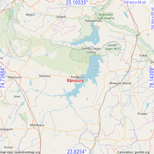
Rāmpura GPS coordinates[2]
24° 28' 1.2" North, 75° 26' 23.856" East
| Map corner | latitude | longitude |
|---|---|---|
| Upper-left | 25.10535°, | 74.73684° |
| Center: | 24.467°, | 75.43996° |
| Lower-right: | 23.8254°, | 76.14309° |
| Map W x H: | 142.3×142.3 km | = 88.4×88.4mi |
| max Lat: | 34.9274° ⇑39.6% North |
| Rāmpura: | 24.467° |
| min Lat: | ⇓60.4% South 8.09008° |
| min Long | Rāmpura | max Long |
| 68.82655° | 75.43996° | 96.81° |
| W 21.1%⇐ | ⇒78.9% E |
Elevation
Elevation of Rāmpura is 411 m = 1348 ft, and this is 115.4 m = 379 ft above average elevation for this country.
| Max E: |
3681 m = 12077 ft | 23.2% |
| Rāmpura | 411 m 1348 ft | |
| Avg. | 295.6 m = 970 ft | |
Min E: |
1 m = 3 ft | 76.8% |
See also: India elevation on elevation.city.
Geographical zone
Rāmpura is located in North temperate zone (between Tropic of Cancer and the Arctic Circle). Distance of this Northern Tropic circle is 114.6 km =71.2 mi to South.| Distance of | km | miles | from Rāmpura |
|---|---|---|---|
| North Pole | 7286.6 | 4527.7 | to North |
| Arctic Circle | 4680.7 | 2908.5 | to North |
| Tropic Cancer | 114.6 | 71.2 | to South |
| Equator | 2720.5 | 1690.4 | to South |


Nearby cities:
15 places around Rāmpura: (largest is in red/bold)
• Bhawāniganj
40.4 km =25.1 mi,  98°
98°
• Bhānpura
31.5 km =19.6 mi,  80°
80°
• Chechat
55.8 km =34.7 mi,  53°
53°
• Jīran
58.3 km =36.2 mi,  252°
252°
• Malhārgarh
49.9 km =31 mi, 245°
• Mandsaur
57.8 km =35.9 mi,  220°
220°
• Manāsa
30.3 km =18.8 mi,  272°
272°
• Nārāyangarh
45.1 km =28 mi,  241°
241°
• Ratangarh
50.8 km =31.6 mi,  319°
319°
• Rāmganj Mandi
54.7 km =34 mi,  68°
68°
• Rāwatbhāta
53.7 km =33.4 mi,  16°
16°
• Shāmgarh
37 km =23 mi,  146°
146°
• Singoli
57.3 km =35.6 mi,  345°
345°
• Sunel
53.4 km =33.2 mi, 101°
• Sītāmau
51.1 km =31.8 mi,  189°
189°
Sources, notices
• [Note1] Compared only with cities in India existing in our database
• [Src1] Map data: © OpenStreetMap contributors (CC-BY-SA)
• [Src2] Other city data from geonames.org with taken over terms of usage.
• [Src3] Geographical zone / Annual Mean Temperature by Robert A. Rohde @ Wikipedia
