Begūn geodata
Begūn (Rajasthan) is a populated place; located in India in Asia/Kolkata (GMT+5.5) time zone. With population of 20,836 people, there are 1976 cities with bigger population in this country. Compared to other cities in India, 63.4% of cities are located further ↓South; 82.8% of cities are located further →East and 77.4% of cities have lower elevation than Begūn. Note1


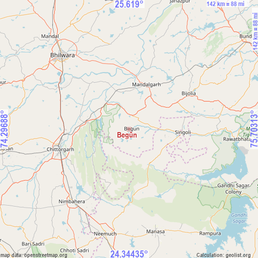
Begūn GPS coordinates[2]
24° 58' 59.988" North, 75° 0' 0" East
| Map corner | latitude | longitude |
|---|---|---|
| Upper-left | 25.619°, | 74.29688° |
| Center: | 24.98333°, | 75° |
| Lower-right: | 24.34435°, | 75.70313° |
| Map W x H: | 141.7×141.7 km | = 88×88mi |
| max Lat: | 34.9274° ⇑36.6% North |
| Begūn: | 24.98333° |
| min Lat: | ⇓63.4% South 8.09008° |
| min Long | Begūn | max Long |
| 68.82655° | 75° | 96.81° |
| W 17.2%⇐ | ⇒82.8% E |
Elevation
Elevation of Begūn is 420 m = 1378 ft, and this is 124.4 m = 408 ft above average elevation for this country.
| Max E: |
3681 m = 12077 ft | 22.6% |
| Begūn | 420 m 1378 ft | |
| Avg. | 295.6 m = 970 ft | |
Min E: |
1 m = 3 ft | 77.4% |
See also: India elevation on elevation.city.
Geographical zone
Begūn is located in North temperate zone (between Tropic of Cancer and the Arctic Circle). Distance of this Northern Tropic circle is 172 km =106.9 mi to South.| Distance of | km | miles | from Begūn |
|---|---|---|---|
| North Pole | 7229.2 | 4492 | to North |
| Arctic Circle | 4623.3 | 2872.8 | to North |
| Tropic Cancer | 172 | 106.9 | to South |
| Equator | 2777.9 | 1726.1 | to South |


Nearby cities:
15 places around Begūn: (largest is in red/bold)
• Bhīlwāra
54.2 km =33.7 mi,  318°
318°
• Chhoti Sādri
73.4 km =45.6 mi,  204°
204°
• Chittaurgarh
39.3 km =24.4 mi,  254°
254°
• Jāwad
44.9 km =27.9 mi, 197°
• Jīran
75.8 km =47.1 mi,  188°
188°
• Manāsa
58 km =36 mi,  165°
165°
• Māndal
66.8 km =41.5 mi, 319°
• Māndalgarh
24.5 km =15.2 mi,  17°
17°
• Neemuch
58.1 km =36.1 mi, 193°
• Nīmbāhera
51.6 km =32.1 mi,  218°
218°
• Ratangarh
22 km =13.7 mi,  147°
147°
• Rāmpura
72.6 km =45.1 mi,  142°
142°
• Rāwatbhāta
60 km =37.3 mi,  95°
95°
• Shāhpura
71.3 km =44.3 mi,  353°
353°
• Singoli
30.3 km =18.8 mi,  93°
93°
Sources, notices
• [Note1] Compared only with cities in India existing in our database
• [Src1] Map data: © OpenStreetMap contributors (CC-BY-SA)
• [Src2] Other city data from geonames.org with taken over terms of usage.
• [Src3] Geographical zone / Annual Mean Temperature by Robert A. Rohde @ Wikipedia
