Soro geodata
Soro (Odisha) is a populated place; located in India in Asia/Kolkata (GMT+5.5) time zone. With population of 29,797 people, there are 1455 cities with bigger population in this country. Compared to other cities in India, 60.2% of cities are located further ↑North; 88.7% of cities are located further ←West and 90.4% of cities have higher elevation than Soro. Note1


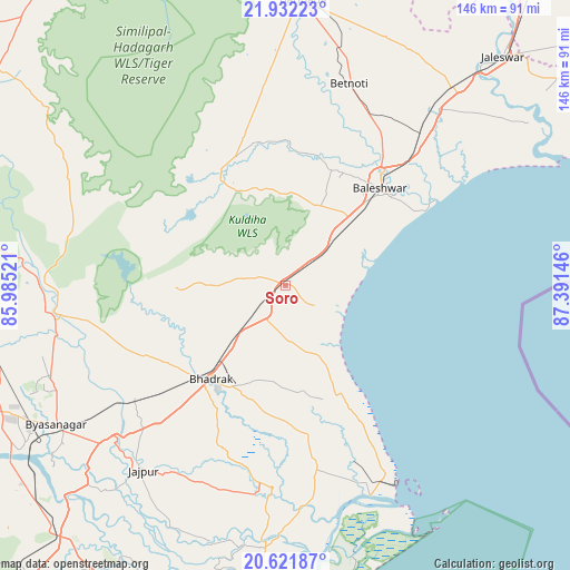
Soro GPS coordinates[2]
21° 16' 42.636" North, 86° 41' 17.988" East
| Map corner | latitude | longitude |
|---|---|---|
| Upper-left | 21.93223°, | 85.98521° |
| Center: | 21.27851°, | 86.68833° |
| Lower-right: | 20.62187°, | 87.39146° |
| Map W x H: | 145.7×145.7 km | = 90.5×90.5mi |
| max Lat: | 34.9274° ⇑60.2% North |
| Soro: | 21.27851° |
| min Lat: | ⇓39.8% South 8.09008° |
| min Long | Soro | max Long |
| 68.82655° | 86.68833° | 96.81° |
| W 88.7%⇐ | ⇒11.3% E |
Elevation
Elevation of Soro is 17 m = 56 ft, and this is 278.6 m = 914 ft below average elevation for this country.
| Max E: |
3681 m = 12077 ft | 90.4% |
| Avg. | 295.6 m = 970 ft | |
| Soro | 17 m = 56 ft | |
Min E: |
1 m = 3 ft | 9.6% |
See also: India elevation on elevation.city.
Geographical zone
Soro is located in North Torrid zone (between Equator and Tropic of Cancer). Distance of this Northern Tropic circle is 240 km =149.1 mi to North.| Distance of | km | miles | from Soro |
|---|---|---|---|
| North Pole | 7641.1 | 4748 | to North |
| Arctic Circle | 5035.2 | 3128.7 | to North |
| Tropic Cancer | 240 | 149.1 | to North |
| Equator | 2365.9 | 1470.1 | to South |


Nearby cities:
15 places around Soro: (largest is in red/bold)
• Balasore
34.8 km =21.6 mi,  46°
46°
• Bhadrakh
30.7 km =19.1 mi,  215°
215°
• Bhuban
99.1 km =61.6 mi,  243°
243°
• Bāsudebpur
18.1 km =11.2 mi,  166°
166°
• Chāndbāli
56.2 km =34.9 mi, 174°
• Daitari
99.3 km =61.7 mi,  258°
258°
• Digha
94.4 km =58.7 mi,  65°
65°
• Egra
111.7 km =69.4 mi, 51°
• Jaleshwar
80.2 km =49.8 mi,  43°
43°
• Jājpur
60.1 km =37.3 mi, 217°
• Kendrāparha
90.7 km =56.4 mi,  197°
197°
• Nīlgiri
22 km =13.7 mi,  21°
21°
• Parādīp Garh
107.3 km =66.7 mi,  184°
184°
• Patāmundai
79 km =49.1 mi,  189°
189°
• Remuna
33.6 km =20.9 mi,  34°
34°
Sources, notices
• [Note1] Compared only with cities in India existing in our database
• [Src1] Map data: © OpenStreetMap contributors (CC-BY-SA)
• [Src2] Other city data from geonames.org with taken over terms of usage.
• [Src3] Geographical zone / Annual Mean Temperature by Robert A. Rohde @ Wikipedia
