Nīlgiri geodata
Nīlgiri (Odisha) is a populated place; located in India in Asia/Kolkata (GMT+5.5) time zone. With population of 15,462 people, there are 2418 cities with bigger population in this country. Compared to other cities in India, 59.2% of cities are located further ↑North; 88.9% of cities are located further ←West and 80.5% of cities have higher elevation than Nīlgiri. Note1


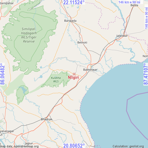
Nīlgiri GPS coordinates[2]
21° 27' 44.46" North, 86° 46' 4.584" East
| Map corner | latitude | longitude |
|---|---|---|
| Upper-left | 22.11524°, | 86.06482° |
| Center: | 21.46235°, | 86.76794° |
| Lower-right: | 20.80652°, | 87.47107° |
| Map W x H: | 145.5×145.5 km | = 90.4×90.4mi |
| max Lat: | 34.9274° ⇑59.2% North |
| Nīlgiri: | 21.46235° |
| min Lat: | ⇓40.8% South 8.09008° |
| min Long | Nīlgiri | max Long |
| 68.82655° | 86.76794° | 96.81° |
| W 88.9%⇐ | ⇒11.1% E |
Elevation
Elevation of Nīlgiri is 46 m = 151 ft, and this is 249.6 m = 819 ft below average elevation for this country.
| Max E: |
3681 m = 12077 ft | 80.5% |
| Avg. | 295.6 m = 970 ft | |
| Nīlgiri | 46 m = 151 ft | |
Min E: |
1 m = 3 ft | 19.5% |
See also: India elevation on elevation.city.
Geographical zone
Nīlgiri is located in North Torrid zone (between Equator and Tropic of Cancer). Distance of this Northern Tropic circle is 219.5 km =136.4 mi to North.| Distance of | km | miles | from Nīlgiri |
|---|---|---|---|
| North Pole | 7620.7 | 4735.3 | to North |
| Arctic Circle | 5014.8 | 3116.1 | to North |
| Tropic Cancer | 219.5 | 136.4 | to North |
| Equator | 2386.4 | 1482.8 | to South |


Nearby cities:
15 places around Nīlgiri: (largest is in red/bold)
• Balasore
17.5 km =10.9 mi,  78°
78°
• Bhadrakh
52.4 km =32.6 mi,  209°
209°
• Bāsudebpur
38.3 km =23.8 mi,  186°
186°
• Chāndbāli
76.5 km =47.5 mi,  182°
182°
• Contai
107.4 km =66.7 mi,  70°
70°
• Digha
79.9 km =49.6 mi, 76°
• Egra
93.2 km =57.9 mi,  58°
58°
• Jaleshwar
60.3 km =37.5 mi,  51°
51°
• Jhārgrām
112.7 km =70 mi,  11°
11°
• Jājpur
81.6 km =50.7 mi, 213°
• Kalaīkunda
108.4 km =67.4 mi,  25°
25°
• Kuchaiburi
108.4 km =67.4 mi,  325°
325°
• Patāmundai
100.7 km =62.6 mi, 192°
• Remuna
13 km =8.1 mi, 55°
• Soro
22 km =13.7 mi,  201°
201°
Sources, notices
• [Note1] Compared only with cities in India existing in our database
• [Src1] Map data: © OpenStreetMap contributors (CC-BY-SA)
• [Src2] Other city data from geonames.org with taken over terms of usage.
• [Src3] Geographical zone / Annual Mean Temperature by Robert A. Rohde @ Wikipedia
