Dhenkānāl geodata
Dhenkānāl (Odisha) is a populated place; located in India in Asia/Kolkata (GMT+5.5) time zone. With population of 62,230 people, there are 707 cities with bigger population in this country. Compared to other cities in India, 63.2% of cities are located further ↑North; 85.9% of cities are located further ←West and 73.4% of cities have higher elevation than Dhenkānāl. Note1


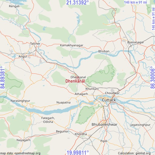
Dhenkānāl GPS coordinates[2]
20° 39' 26.784" North, 85° 35' 48.948" East
| Map corner | latitude | longitude |
|---|---|---|
| Upper-left | 21.31392°, | 84.89381° |
| Center: | 20.65744°, | 85.59693° |
| Lower-right: | 19.99811°, | 86.30006° |
| Map W x H: | 146.3×146.3 km | = 90.9×90.9mi |
| max Lat: | 34.9274° ⇑63.2% North |
| Dhenkānāl: | 20.65744° |
| min Lat: | ⇓36.8% South 8.09008° |
| min Long | Dhenkānāl | max Long |
| 68.82655° | 85.59693° | 96.81° |
| W 85.9%⇐ | ⇒14.1% E |
Elevation
Elevation of Dhenkānāl is 77 m = 253 ft, and this is 218.6 m = 717 ft below average elevation for this country.
| Max E: |
3681 m = 12077 ft | 73.4% |
| Avg. | 295.6 m = 970 ft | |
| Dhenkānāl | 77 m = 253 ft | |
Min E: |
1 m = 3 ft | 26.6% |
See also: Dhenkānāl elevation on elevation.city.
Geographical zone
Dhenkānāl is located in North Torrid zone (between Equator and Tropic of Cancer). Distance of this Northern Tropic circle is 309 km =192 mi to North.| Distance of | km | miles | from Dhenkānāl |
|---|---|---|---|
| North Pole | 7710.2 | 4790.9 | to North |
| Arctic Circle | 5104.3 | 3171.7 | to North |
| Tropic Cancer | 309 | 192 | to North |
| Equator | 2296.9 | 1427.2 | to South |


Nearby cities:
15 places around Dhenkānāl: (largest is in red/bold)
• Angul
55.4 km =34.4 mi,  291°
291°
• Bhuban
35 km =21.7 mi,  44°
44°
• Bhubaneshwar
49.4 km =30.7 mi,  150°
150°
• Bālugaon
73.3 km =45.5 mi,  223°
223°
• Bānki
31.7 km =19.7 mi,  192°
192°
• Cuttack
36.4 km =22.6 mi,  126°
126°
• Daitari
51.7 km =32.1 mi,  17°
17°
• Jagatsinghapur
74.7 km =46.4 mi, 126°
• Jatani
56.5 km =35.1 mi,  168°
168°
• Kantilo
53.5 km =33.2 mi,  232°
232°
• Khurda
52.8 km =32.8 mi,  177°
177°
• Kāmākhyānagar
31.2 km =19.4 mi,  350°
350°
• Pipili
65.2 km =40.5 mi,  157°
157°
• Tālcher
49.8 km =30.9 mi,  310°
310°
• Āthagarh
15.7 km =9.8 mi, 167°
Sources, notices
• [Note1] Compared only with cities in India existing in our database
• [Src1] Map data: © OpenStreetMap contributors (CC-BY-SA)
• [Src2] Other city data from geonames.org with taken over terms of usage.
• [Src3] Geographical zone / Annual Mean Temperature by Robert A. Rohde @ Wikipedia
