Bayāna geodata
Bayāna (Rajasthan) is a populated place; located in India in Asia/Kolkata (GMT+5.5) time zone. With population of 36,399 people, there are 1204 cities with bigger population in this country. Compared to other cities in India, 77.7% of cities are located further ↓South; 60% of cities are located further →East and 51.4% of cities have lower elevation than Bayāna. Note1


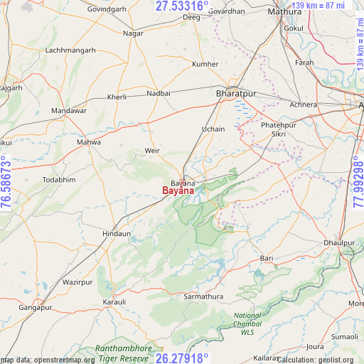
Bayāna GPS coordinates[2]
26° 54' 28.476" North, 77° 17' 23.46" East
| Map corner | latitude | longitude |
|---|---|---|
| Upper-left | 27.53316°, | 76.58673° |
| Center: | 26.90791°, | 77.28985° |
| Lower-right: | 26.27918°, | 77.99298° |
| Map W x H: | 139.4×139.4 km | = 86.6×86.6mi |
| max Lat: | 34.9274° ⇑22.3% North |
| Bayāna: | 26.90791° |
| min Lat: | ⇓77.7% South 8.09008° |
| min Long | Bayāna | max Long |
| 68.82655° | 77.28985° | 96.81° |
| W 40%⇐ | ⇒60% E |
Elevation
Elevation of Bayāna is 210 m = 689 ft, and this is 85.6 m = 281 ft below average elevation for this country.
| Max E: |
3681 m = 12077 ft | 48.6% |
| Avg. | 295.6 m = 970 ft | |
| Bayāna | 210 m = 689 ft | |
Min E: |
1 m = 3 ft | 51.4% |
See also: India elevation on elevation.city.
Geographical zone
Bayāna is located in North temperate zone (between Tropic of Cancer and the Arctic Circle). Distance of this Northern Tropic circle is 386 km =239.8 mi to South.| Distance of | km | miles | from Bayāna |
|---|---|---|---|
| North Pole | 7015.2 | 4359 | to North |
| Arctic Circle | 4409.3 | 2739.8 | to North |
| Tropic Cancer | 386 | 239.8 | to South |
| Equator | 2991.9 | 1859.1 | to South |


Nearby cities:
15 places around Bayāna: (largest is in red/bold)
• Achhnera
55.1 km =34.2 mi,  56°
56°
• Bharatpur
39.7 km =24.7 mi,  29°
29°
• Bhasāwar
28 km =17.4 mi,  301°
301°
• Bāri
43.5 km =27 mi,  131°
131°
• Fatehpur Sīkri
42.1 km =26.2 mi, 60°
• Hindaun
31.8 km =19.8 mi,  232°
232°
• Jagnair
31.4 km =19.5 mi,  99°
99°
• Karauli
52.5 km =32.6 mi,  209°
209°
• Khairāgarh
52.6 km =32.7 mi,  85°
85°
• Kiraoli
55.3 km =34.4 mi, 62°
• Kūmher
46.1 km =28.6 mi,  9°
9°
• Mahwah
38.7 km =24 mi,  293°
293°
• Nādbai
36.2 km =22.5 mi,  345°
345°
• Todabhim
46.9 km =29.1 mi,  271°
271°
• Wer
16.7 km =10.4 mi,  317°
317°
Sources, notices
• [Note1] Compared only with cities in India existing in our database
• [Src1] Map data: © OpenStreetMap contributors (CC-BY-SA)
• [Src2] Other city data from geonames.org with taken over terms of usage.
• [Src3] Geographical zone / Annual Mean Temperature by Robert A. Rohde @ Wikipedia
