Achhnera geodata
Achhnera (Uttar Pradesh) is a populated place; located in India in Asia/Kolkata (GMT+5.5) time zone. With population of 20,532 people, there are 1999 cities with bigger population in this country. Compared to other cities in India, 79.9% of cities are located further ↓South; 54.3% of cities are located further →East and 54.8% of cities have higher elevation than Achhnera. Note1


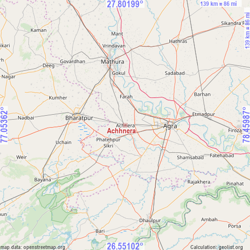
Achhnera GPS coordinates[2]
27° 10' 41.736" North, 77° 45' 24.264" East
| Map corner | latitude | longitude |
|---|---|---|
| Upper-left | 27.80199°, | 77.05362° |
| Center: | 27.17826°, | 77.75674° |
| Lower-right: | 26.55102°, | 78.45987° |
| Map W x H: | 139.1×139.1 km | = 86.4×86.4mi |
| max Lat: | 34.9274° ⇑20.1% North |
| Achhnera: | 27.17826° |
| min Lat: | ⇓79.9% South 8.09008° |
| min Long | Achhnera | max Long |
| 68.82655° | 77.75674° | 96.81° |
| W 45.7%⇐ | ⇒54.3% E |
Elevation
Elevation of Achhnera is 176 m = 577 ft, and this is 119.6 m = 392 ft below average elevation for this country.
| Max E: |
3681 m = 12077 ft | 54.8% |
| Avg. | 295.6 m = 970 ft | |
| Achhnera | 176 m = 577 ft | |
Min E: |
1 m = 3 ft | 45.2% |
See also: India elevation on elevation.city.
Geographical zone
Achhnera is located in North temperate zone (between Tropic of Cancer and the Arctic Circle). Distance of this Northern Tropic circle is 416 km =258.5 mi to South.| Distance of | km | miles | from Achhnera |
|---|---|---|---|
| North Pole | 6985.1 | 4340.3 | to North |
| Arctic Circle | 4379.2 | 2721.1 | to North |
| Tropic Cancer | 416 | 258.5 | to South |
| Equator | 3021.9 | 1877.7 | to South |


Nearby cities:
15 places around Achhnera: (largest is in red/bold)
• Agra
25.7 km =16 mi,  88°
88°
• Baldev
26.2 km =16.3 mi,  14°
14°
• Bharatpur
26.7 km =16.6 mi,  279°
279°
• Dayāl Bāgh
25.6 km =15.9 mi,  79°
79°
• Farah
15.9 km =9.9 mi,  1°
1°
• Fatehpur Sīkri
13.4 km =8.3 mi,  225°
225°
• Gokul
29.2 km =18.1 mi,  352°
352°
• Jagnair
38.2 km =23.7 mi,  203°
203°
• Khairāgarh
26.9 km =16.7 mi,  166°
166°
• Kiraoli
5.3 km =3.3 mi,  148°
148°
• Kūmher
41.1 km =25.5 mi,  291°
291°
• Mahāban
28.3 km =17.6 mi,  357°
357°
• Mathura
37.1 km =23.1 mi, 346°
• Sadābād
40.1 km =24.9 mi,  43°
43°
• Shamsābād
40.5 km =25.2 mi,  116°
116°
Sources, notices
• [Note1] Compared only with cities in India existing in our database
• [Src1] Map data: © OpenStreetMap contributors (CC-BY-SA)
• [Src2] Other city data from geonames.org with taken over terms of usage.
• [Src3] Geographical zone / Annual Mean Temperature by Robert A. Rohde @ Wikipedia
