Wer geodata
Wer (Rajasthan) is a populated place; located in India in Asia/Kolkata (GMT+5.5) time zone. With population of 18,268 people, there are 2181 cities with bigger population in this country. Compared to other cities in India, 78.5% of cities are located further ↓South; 61.2% of cities are located further →East and 54% of cities have lower elevation than Wer. Note1


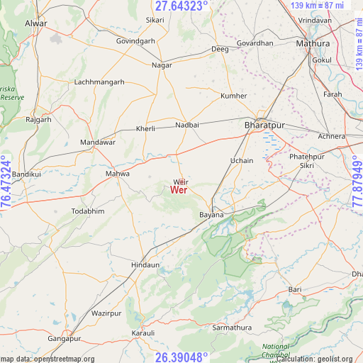
Wer GPS coordinates[2]
27° 1' 6.96" North, 77° 10' 34.896" East
| Map corner | latitude | longitude |
|---|---|---|
| Upper-left | 27.64323°, | 76.47324° |
| Center: | 27.0186°, | 77.17636° |
| Lower-right: | 26.39048°, | 77.87949° |
| Map W x H: | 139.3×139.3 km | = 86.6×86.6mi |
| max Lat: | 34.9274° ⇑21.5% North |
| Wer: | 27.0186° |
| min Lat: | ⇓78.5% South 8.09008° |
| min Long | Wer | max Long |
| 68.82655° | 77.17636° | 96.81° |
| W 38.8%⇐ | ⇒61.2% E |
Elevation
Elevation of Wer is 222 m = 728 ft, and this is 73.6 m = 241 ft below average elevation for this country.
| Max E: |
3681 m = 12077 ft | 46% |
| Avg. | 295.6 m = 970 ft | |
| Wer | 222 m = 728 ft | |
Min E: |
1 m = 3 ft | 54% |
See also: India elevation on elevation.city.
Geographical zone
Wer is located in North temperate zone (between Tropic of Cancer and the Arctic Circle). Distance of this Northern Tropic circle is 398.3 km =247.5 mi to South.| Distance of | km | miles | from Wer |
|---|---|---|---|
| North Pole | 7002.9 | 4351.4 | to North |
| Arctic Circle | 4397 | 2732.2 | to North |
| Tropic Cancer | 398.3 | 247.5 | to South |
| Equator | 3004.2 | 1866.7 | to South |


Nearby cities:
15 places around Wer: (largest is in red/bold)
• Abhaneri
56.4 km =35 mi,  268°
268°
• Bayāna
16.7 km =10.4 mi,  137°
137°
• Bharatpur
38.1 km =23.7 mi,  54°
54°
• Bhasāwar
12.9 km =8 mi,  280°
280°
• Dīg
52.5 km =32.6 mi,  16°
16°
• Fatehpur Sīkri
48.6 km =30.2 mi,  80°
80°
• Govindgarh
56.8 km =35.3 mi,  342°
342°
• Hindaun
34.6 km =21.5 mi,  203°
203°
• Jagnair
45.6 km =28.3 mi,  112°
112°
• Karauli
59.7 km =37.1 mi,  194°
194°
• Kūmher
38.3 km =23.8 mi,  30°
30°
• Mahwah
24.4 km =15.2 mi, 277°
• Nagar
45.7 km =28.4 mi,  350°
350°
• Nādbai
22.8 km =14.2 mi,  4°
4°
• Todabhim
37.4 km =23.2 mi,  252°
252°
Sources, notices
• [Note1] Compared only with cities in India existing in our database
• [Src1] Map data: © OpenStreetMap contributors (CC-BY-SA)
• [Src2] Other city data from geonames.org with taken over terms of usage.
• [Src3] Geographical zone / Annual Mean Temperature by Robert A. Rohde @ Wikipedia
