Islāmpur geodata
Islāmpur (West Bengal) is a populated place; located in India in Asia/Kolkata (GMT+5.5) time zone. With population of 55,691 people, there are 801 cities with bigger population in this country. Compared to other cities in India, 72.6% of cities are located further ↓South; 91.8% of cities are located further ←West and 74.6% of cities have higher elevation than Islāmpur. Note1


Islāmpur GPS coordinates[2]
26° 15' 55.476" North, 88° 11' 23.352" East
| Map corner | latitude | longitude |
|---|---|---|
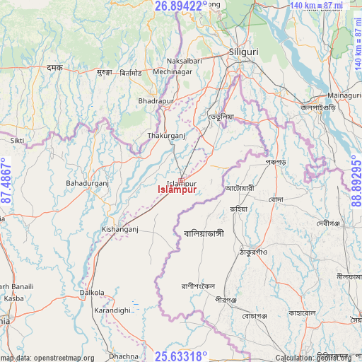
| Upper-left | 26.89422°, | 87.4867° |
| Center: | 26.26541°, | 88.18982° |
| Lower-right: | 25.63318°, | 88.89295° |
| Map W x H: | 140.2×140.2 km | = 87.1×87.1mi |
| max Lat: | 34.9274° ⇑27.4% North |
| Islāmpur: | 26.26541° |
| min Lat: | ⇓72.6% South 8.09008° |
| min Long | Islāmpur | max Long |
| 68.82655° | 88.18982° | 96.81° |
| W 91.8%⇐ | ⇒8.2% E |
Elevation
Elevation of Islāmpur is 70 m = 230 ft, and this is 225.6 m = 740 ft below average elevation for this country.
| Max E: |
3681 m = 12077 ft | 74.6% |
| Avg. | 295.6 m = 970 ft | |
| Islāmpur | 70 m = 230 ft | |
Min E: |
1 m = 3 ft | 25.4% |
See also: Islāmpur elevation on elevation.city.
Geographical zone
Islāmpur is located in North temperate zone (between Tropic of Cancer and the Arctic Circle). Distance of this Northern Tropic circle is 314.5 km =195.4 mi to South.| Distance of | km | miles | from Islāmpur |
|---|---|---|---|
| North Pole | 7086.6 | 4403.4 | to North |
| Arctic Circle | 4480.7 | 2784.2 | to North |
| Tropic Cancer | 314.5 | 195.4 | to South |
| Equator | 2920.4 | 1814.7 | to South |


Nearby cities:
15 places around Islāmpur: (largest is in red/bold)
• Arāria
68.7 km =42.7 mi,  259°
259°
• Bagdogra
49.7 km =30.9 mi,  14°
14°
• Bahādurganj
36.4 km =22.6 mi,  269°
269°
• Baisi
63.1 km =39.2 mi,  224°
224°
• Dalkola
55.7 km =34.6 mi, 218°
• Haldībāri
59.6 km =37 mi,  82°
82°
• Jalpāiguri
60.9 km =37.8 mi,  62°
62°
• Kishanganj
29.6 km =18.4 mi,  232°
232°
• Kāliyāganj
71.5 km =44.4 mi,  168°
168°
• Kārsiyāng
69.2 km =43 mi, 7°
• Maināguri
71 km =44.1 mi, 62°
• Mirik
69.2 km =43 mi,  0°
0°
• Naksalbāri
46.5 km =28.9 mi, 3°
• Siliguri
54.8 km =34.1 mi,  25°
25°
• Thākurganj
18.9 km =11.7 mi,  342°
342°
Sources, notices
• [Note1] Compared only with cities in India existing in our database
• [Src1] Map data: © OpenStreetMap contributors (CC-BY-SA)
• [Src2] Other city data from geonames.org with taken over terms of usage.
• [Src3] Geographical zone / Annual Mean Temperature by Robert A. Rohde @ Wikipedia
