Kishanganj geodata
Kishanganj (Bihar) is a populated place; located in India in Asia/Kolkata (GMT+5.5) time zone. With population of 94,807 people, there are 469 cities with bigger population in this country. Compared to other cities in India, 71.1% of cities are located further ↓South; 91.1% of cities are located further ←West and 77.5% of cities have higher elevation than Kishanganj. Note1


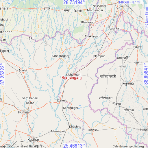
Kishanganj GPS coordinates[2]
26° 6' 8.064" North, 87° 57' 19.224" East
| Map corner | latitude | longitude |
|---|---|---|
| Upper-left | 26.73194°, | 87.25222° |
| Center: | 26.10224°, | 87.95534° |
| Lower-right: | 25.46913°, | 88.65847° |
| Map W x H: | 140.4×140.4 km | = 87.2×87.2mi |
| max Lat: | 34.9274° ⇑28.9% North |
| Kishanganj: | 26.10224° |
| min Lat: | ⇓71.1% South 8.09008° |
| min Long | Kishanganj | max Long |
| 68.82655° | 87.95534° | 96.81° |
| W 91.1%⇐ | ⇒8.9% E |
Elevation
Elevation of Kishanganj is 57 m = 187 ft, and this is 238.6 m = 783 ft below average elevation for this country.
| Max E: |
3681 m = 12077 ft | 77.5% |
| Avg. | 295.6 m = 970 ft | |
| Kishanganj | 57 m = 187 ft | |
Min E: |
1 m = 3 ft | 22.5% |
See also: Kishanganj elevation on elevation.city.
Geographical zone
Kishanganj is located in North temperate zone (between Tropic of Cancer and the Arctic Circle). Distance of this Northern Tropic circle is 296.4 km =184.2 mi to South.| Distance of | km | miles | from Kishanganj |
|---|---|---|---|
| North Pole | 7104.8 | 4414.7 | to North |
| Arctic Circle | 4498.9 | 2795.5 | to North |
| Tropic Cancer | 296.4 | 184.2 | to South |
| Equator | 2902.3 | 1803.4 | to South |


Nearby cities:
15 places around Kishanganj: (largest is in red/bold)
• Arāria
44.4 km =27.6 mi,  276°
276°
• Bahādurganj
22 km =13.7 mi,  323°
323°
• Baisi
33.9 km =21.1 mi,  218°
218°
• Dalkola
27.7 km =17.2 mi,  204°
204°
• Forbesganj
72.3 km =44.9 mi,  287°
287°
• Islāmpur
29.6 km =18.4 mi,  52°
52°
• Kasba
49.8 km =30.9 mi,  236°
236°
• Katihar
73.6 km =45.7 mi,  211°
211°
• Kāliyāganj
63.9 km =39.7 mi,  144°
144°
• Naksalbāri
69.7 km =43.3 mi,  22°
22°
• Purnia
60.1 km =37.3 mi,  233°
233°
• Raghunāthpur
51 km =31.7 mi,  184°
184°
• Rāiganj
57 km =35.4 mi,  162°
162°
• Shahbazpur
70.2 km =43.6 mi, 288°
• Thākurganj
40.2 km =25 mi,  25°
25°
Sources, notices
• [Note1] Compared only with cities in India existing in our database
• [Src1] Map data: © OpenStreetMap contributors (CC-BY-SA)
• [Src2] Other city data from geonames.org with taken over terms of usage.
• [Src3] Geographical zone / Annual Mean Temperature by Robert A. Rohde @ Wikipedia
