Arāria geodata
Arāria (Bihar) is a populated place; located in India in Asia/Kolkata (GMT+5.5) time zone. With population of 67,474 people, there are 643 cities with bigger population in this country. Compared to other cities in India, 71.5% of cities are located further ↓South; 90.1% of cities are located further ←West and 77.7% of cities have higher elevation than Arāria. Note1


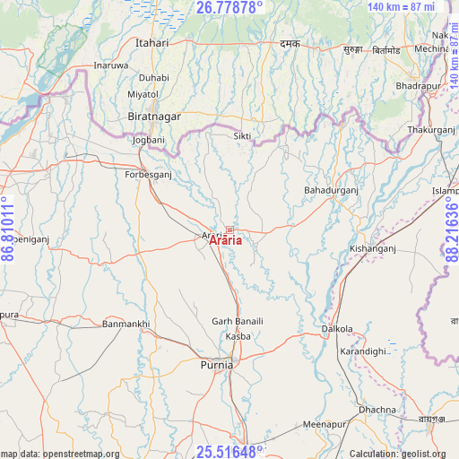
Arāria GPS coordinates[2]
26° 8' 57.624" North, 87° 30' 47.628" East
| Map corner | latitude | longitude |
|---|---|---|
| Upper-left | 26.77878°, | 86.81011° |
| Center: | 26.14934°, | 87.51323° |
| Lower-right: | 25.51648°, | 88.21636° |
| Map W x H: | 140.4×140.4 km | = 87.2×87.2mi |
| max Lat: | 34.9274° ⇑28.5% North |
| Arāria: | 26.14934° |
| min Lat: | ⇓71.5% South 8.09008° |
| min Long | Arāria | max Long |
| 68.82655° | 87.51323° | 96.81° |
| W 90.1%⇐ | ⇒9.9% E |
Elevation
Elevation of Arāria is 56 m = 184 ft, and this is 239.6 m = 786 ft below average elevation for this country.
| Max E: |
3681 m = 12077 ft | 77.7% |
| Avg. | 295.6 m = 970 ft | |
| Arāria | 56 m = 184 ft | |
Min E: |
1 m = 3 ft | 22.3% |
See also: Arāria elevation on elevation.city.
Geographical zone
Arāria is located in North temperate zone (between Tropic of Cancer and the Arctic Circle). Distance of this Northern Tropic circle is 301.6 km =187.4 mi to South.| Distance of | km | miles | from Arāria |
|---|---|---|---|
| North Pole | 7099.5 | 4411.4 | to North |
| Arctic Circle | 4493.6 | 2792.2 | to North |
| Tropic Cancer | 301.6 | 187.4 | to South |
| Equator | 2907.5 | 1806.6 | to South |


Nearby cities:
15 places around Arāria: (largest is in red/bold)
• Bahādurganj
33.5 km =20.8 mi,  68°
68°
• Baisi
39.4 km =24.5 mi,  143°
143°
• Banmankhi
43.1 km =26.8 mi,  227°
227°
• Bhawanipur
59.1 km =36.7 mi,  304°
304°
• Bīrpur
63.9 km =39.7 mi,  308°
308°
• Chhātāpur
51.3 km =31.9 mi,  278°
278°
• Dalkola
44.6 km =27.7 mi,  132°
132°
• Forbesganj
30 km =18.6 mi, 304°
• Jogbani
37.2 km =23.1 mi,  318°
318°
• Kasba
32.7 km =20.3 mi,  175°
175°
• Katihar
68.2 km =42.4 mi, 175°
• Kishanganj
44.4 km =27.6 mi,  96°
96°
• Murlīganj
58.8 km =36.5 mi,  241°
241°
• Purnia
41.4 km =25.7 mi,  185°
185°
• Shahbazpur
28.3 km =17.6 mi, 307°
Sources, notices
• [Note1] Compared only with cities in India existing in our database
• [Src1] Map data: © OpenStreetMap contributors (CC-BY-SA)
• [Src2] Other city data from geonames.org with taken over terms of usage.
• [Src3] Geographical zone / Annual Mean Temperature by Robert A. Rohde @ Wikipedia
