Haldībāri geodata
Haldībāri (West Bengal) is a populated place; located in India in Asia/Kolkata (GMT+5.5) time zone. With population of 14,099 people, there are 2553 cities with bigger population in this country. Compared to other cities in India, 73.4% of cities are located further ↓South; 95% of cities are located further ←West and 73.6% of cities have higher elevation than Haldībāri. Note1


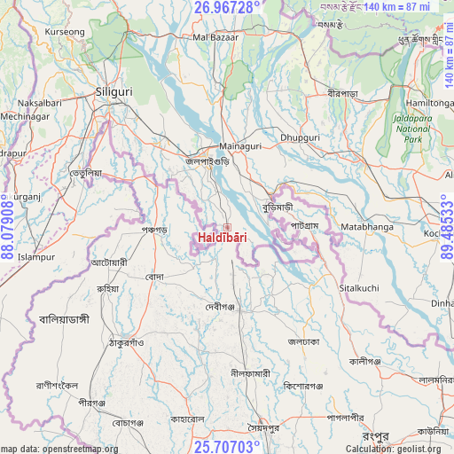
Haldībāri GPS coordinates[2]
26° 20' 19.932" North, 88° 46' 55.92" East
| Map corner | latitude | longitude |
|---|---|---|
| Upper-left | 26.96728°, | 88.07908° |
| Center: | 26.33887°, | 88.7822° |
| Lower-right: | 25.70703°, | 89.48533° |
| Map W x H: | 140.1×140.1 km | = 87.1×87.1mi |
| max Lat: | 34.9274° ⇑26.6% North |
| Haldībāri: | 26.33887° |
| min Lat: | ⇓73.4% South 8.09008° |
| min Long | Haldībāri | max Long |
| 68.82655° | 88.7822° | 96.81° |
| W 95%⇐ | ⇒5% E |
Elevation
Elevation of Haldībāri is 76 m = 249 ft, and this is 219.6 m = 720 ft below average elevation for this country.
| Max E: |
3681 m = 12077 ft | 73.6% |
| Avg. | 295.6 m = 970 ft | |
| Haldībāri | 76 m = 249 ft | |
Min E: |
1 m = 3 ft | 26.4% |
See also: India elevation on elevation.city.
Geographical zone
Haldībāri is located in North temperate zone (between Tropic of Cancer and the Arctic Circle). Distance of this Northern Tropic circle is 322.7 km =200.5 mi to South.| Distance of | km | miles | from Haldībāri |
|---|---|---|---|
| North Pole | 7078.5 | 4398.4 | to North |
| Arctic Circle | 4472.6 | 2779.1 | to North |
| Tropic Cancer | 322.7 | 200.5 | to South |
| Equator | 2928.6 | 1819.7 | to South |


Nearby cities:
15 places around Haldībāri: (largest is in red/bold)
• Bagdogra
61.6 km =38.3 mi,  310°
310°
• Birpara
54.4 km =33.8 mi,  41°
41°
• Dhupgāri
35.7 km =22.2 mi, 38°
• Dīnhāta
71.4 km =44.4 mi,  108°
108°
• Fālākāta
46.6 km =29 mi,  64°
64°
• Goyerkāta
46.9 km =29.1 mi,  31°
31°
• Islāmpur
59.6 km =37 mi,  262°
262°
• Jalpāiguri
20.4 km =12.7 mi,  346°
346°
• Koch Bihār
66.1 km =41.1 mi,  91°
91°
• Maināguri
25.2 km =15.7 mi,  8°
8°
• Mātābhānga
43.2 km =26.8 mi, 89°
• Naksalbāri
67.8 km =42.1 mi,  304°
304°
• Odlābāri
57.4 km =35.7 mi,  344°
344°
• Siliguri
54.2 km =33.7 mi,  319°
319°
• Thākurganj
65.6 km =40.8 mi,  278°
278°
Sources, notices
• [Note1] Compared only with cities in India existing in our database
• [Src1] Map data: © OpenStreetMap contributors (CC-BY-SA)
• [Src2] Other city data from geonames.org with taken over terms of usage.
• [Src3] Geographical zone / Annual Mean Temperature by Robert A. Rohde @ Wikipedia
