Ozar geodata
Ozar (Maharashtra) is a populated place; located in India in Asia/Kolkata (GMT+5.5) time zone. With population of 44,935 people, there are 988 cities with bigger population in this country. Compared to other cities in India, 64.9% of cities are located further ↑North; 90% of cities are located further →East and 87.9% of cities have lower elevation than Ozar. Note1


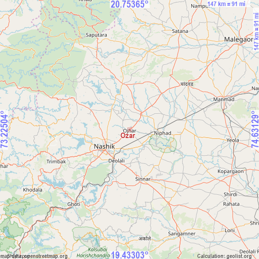
Ozar GPS coordinates[2]
20° 5' 41.028" North, 73° 55' 41.376" East
| Map corner | latitude | longitude |
|---|---|---|
| Upper-left | 20.75365°, | 73.22504° |
| Center: | 20.09473°, | 73.92816° |
| Lower-right: | 19.43303°, | 74.63129° |
| Map W x H: | 146.8×146.8 km | = 91.2×91.2mi |
| max Lat: | 34.9274° ⇑64.9% North |
| Ozar: | 20.09473° |
| min Lat: | ⇓35.1% South 8.09008° |
| min Long | Ozar | max Long |
| 68.82655° | 73.92816° | 96.81° |
| W 10%⇐ | ⇒90% E |
Elevation
Elevation of Ozar is 591 m = 1939 ft, and this is 295.4 m = 969 ft above average elevation for this country.
| Max E: |
3681 m = 12077 ft | 12.1% |
| Ozar | 591 m 1939 ft | |
| Avg. | 295.6 m = 970 ft | |
Min E: |
1 m = 3 ft | 87.9% |
See also: Ozar elevation on elevation.city.
Geographical zone
Ozar is located in North Torrid zone (between Equator and Tropic of Cancer). Distance of this Northern Tropic circle is 371.6 km =230.9 mi to North.| Distance of | km | miles | from Ozar |
|---|---|---|---|
| North Pole | 7772.7 | 4829.7 | to North |
| Arctic Circle | 5166.8 | 3210.5 | to North |
| Tropic Cancer | 371.6 | 230.9 | to North |
| Equator | 2234.3 | 1388.3 | to South |


Nearby cities:
15 places around Ozar: (largest is in red/bold)
• Chāndor
42.2 km =26.2 mi,  51°
51°
• Deolāli
19.4 km =12.1 mi,  210°
210°
• Ghoti Budrukh
52.5 km =32.6 mi,  216°
216°
• Igatpuri
58.6 km =36.4 mi, 220°
• Kopargaon
61.9 km =38.5 mi,  112°
112°
• Lāsalgaon
32.9 km =20.4 mi,  80°
80°
• Manmād
56 km =34.8 mi,  71°
71°
• Nashik
18 km =11.2 mi,  232°
232°
• Sangamner
65.7 km =40.8 mi,  153°
153°
• Satānā
62.6 km =38.9 mi,  27°
27°
• Shirdi
68 km =42.3 mi,  122°
122°
• Sinnar
28.7 km =17.8 mi,  165°
165°
• Surgāna
59.9 km =37.2 mi,  329°
329°
• Trimbak
45.4 km =28.2 mi,  246°
246°
• Yeola
58.9 km =36.6 mi,  95°
95°
Sources, notices
• [Note1] Compared only with cities in India existing in our database
• [Src1] Map data: © OpenStreetMap contributors (CC-BY-SA)
• [Src2] Other city data from geonames.org with taken over terms of usage.
• [Src3] Geographical zone / Annual Mean Temperature by Robert A. Rohde @ Wikipedia
