Nashik geodata
Nashik (Maharashtra) is a seat of a second-order administrative division; located in India in Asia/Kolkata (GMT+5.5) time zone. With population of 1,289,497 people, there are 23 cities with bigger population in this country. Compared to other cities in India, 65.2% of cities are located further ↑North; 91.3% of cities are located further →East and 87.3% of cities have lower elevation than Nashik. Note1


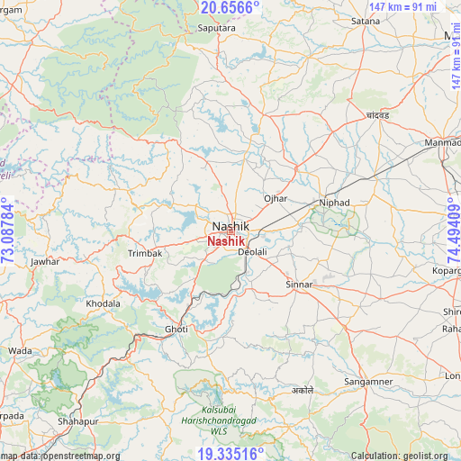
Nashik GPS coordinates[2]
19° 59' 50.172" North, 73° 47' 27.456" East
| Map corner | latitude | longitude |
|---|---|---|
| Upper-left | 20.6566°, | 73.08784° |
| Center: | 19.99727°, | 73.79096° |
| Lower-right: | 19.33516°, | 74.49409° |
| Map W x H: | 146.9×146.9 km | = 91.3×91.3mi |
| max Lat: | 34.9274° ⇑65.2% North |
| Nashik: | 19.99727° |
| min Lat: | ⇓34.8% South 8.09008° |
| min Long | Nashik | max Long |
| 68.82655° | 73.79096° | 96.81° |
| W 8.7%⇐ | ⇒91.3% E |
Elevation
Elevation of Nashik is 584 m = 1916 ft, and this is 288.4 m = 946 ft above average elevation for this country.
| Max E: |
3681 m = 12077 ft | 12.7% |
| Nashik | 584 m 1916 ft | |
| Avg. | 295.6 m = 970 ft | |
Min E: |
1 m = 3 ft | 87.3% |
See also: Nashik elevation on elevation.city.
Geographical zone
Nashik is located in North Torrid zone (between Equator and Tropic of Cancer). Distance of this Northern Tropic circle is 382.4 km =237.6 mi to North.| Distance of | km | miles | from Nashik |
|---|---|---|---|
| North Pole | 7783.6 | 4836.5 | to North |
| Arctic Circle | 5177.7 | 3217.3 | to North |
| Tropic Cancer | 382.4 | 237.6 | to North |
| Equator | 2223.5 | 1381.6 | to South |


Nearby cities:
15 places around Nashik: (largest is in red/bold)
• Chāndor
60.1 km =37.3 mi,  51°
51°
• Deolāli
7.5 km =4.7 mi,  142°
142°
• Ghoti Budrukh
35.6 km =22.1 mi,  208°
208°
• Igatpuri
41.2 km =25.6 mi,  215°
215°
• Jawhār
59.7 km =37.1 mi,  260°
260°
• Kopargaon
72.7 km =45.2 mi,  100°
100°
• Lāsalgaon
49.6 km =30.8 mi,  70°
70°
• Manmād
73.3 km =45.5 mi, 67°
• Ozar
18 km =11.2 mi, 52°
• Sangamner
64.9 km =40.3 mi, 137°
• Shirdi
76.2 km =47.3 mi,  109°
109°
• Sinnar
27.5 km =17.1 mi,  127°
127°
• Surgāna
64.5 km =40.1 mi,  345°
345°
• Trimbak
28.3 km =17.6 mi, 255°
• Yeola
73.1 km =45.4 mi,  86°
86°
Sources, notices
• [Note1] Compared only with cities in India existing in our database
• [Src1] Map data: © OpenStreetMap contributors (CC-BY-SA)
• [Src2] Other city data from geonames.org with taken over terms of usage.
• [Src3] Geographical zone / Annual Mean Temperature by Robert A. Rohde @ Wikipedia
