Koppa geodata
Koppa (Karnataka) is a populated place; located in India in Asia/Kolkata (GMT+5.5) time zone. With population of 5,124 people, there are 3337 cities with bigger population in this country. Compared to other cities in India, 84.3% of cities are located further ↑North; 79.5% of cities are located further →East and 93.6% of cities have lower elevation than Koppa. Note1


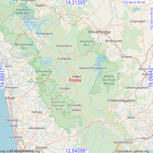
Koppa GPS coordinates[2]
13° 31' 49.584" North, 75° 21' 47.844" East
| Map corner | latitude | longitude |
|---|---|---|
| Upper-left | 14.21305°, | 74.66017° |
| Center: | 13.53044°, | 75.36329° |
| Lower-right: | 12.84586°, | 76.06642° |
| Map W x H: | 152×152 km | = 94.4×94.4mi |
| max Lat: | 34.9274° ⇑84.3% North |
| Koppa: | 13.53044° |
| min Lat: | ⇓15.7% South 8.09008° |
| min Long | Koppa | max Long |
| 68.82655° | 75.36329° | 96.81° |
| W 20.5%⇐ | ⇒79.5% E |
Elevation
Elevation of Koppa is 778 m = 2552 ft, and this is 482.4 m = 1583 ft above average elevation for this country.
| Max E: |
3681 m = 12077 ft | 6.4% |
| Koppa | 778 m 2552 ft | |
| Avg. | 295.6 m = 970 ft | |
Min E: |
1 m = 3 ft | 93.6% |
See also: India elevation on elevation.city.
Geographical zone
Koppa is located in North Torrid zone (between Equator and Tropic of Cancer). Distance of this Northern Tropic circle is 1101.5 km =684.4 mi to North.| Distance of | km | miles | from Koppa |
|---|---|---|---|
| North Pole | 8502.6 | 5283.3 | to North |
| Arctic Circle | 5896.7 | 3664 | to North |
| Tropic Cancer | 1101.5 | 684.4 | to North |
| Equator | 1504.4 | 934.8 | to South |


Nearby cities:
15 places around Koppa: (largest is in red/bold)
• Beltangadi
50.8 km =31.6 mi,  352°
352°
• Bhadrāvati
51.1 km =31.8 mi,  46°
46°
• Chikmagalūr
50.1 km =31.1 mi,  117°
117°
• Hosanagara
53.4 km =33.2 mi,  322°
322°
• Hosangadi
47.9 km =29.8 mi,  292°
292°
• Kumsi
58.4 km =36.3 mi,  3°
3°
• Kārkala
53.3 km =33.1 mi,  228°
228°
• Mudgere
53.4 km =33.2 mi,  145°
145°
• Mūdbidri
65.2 km =40.5 mi,  217°
217°
• Narasimharājapura
18.4 km =11.4 mi,  60°
60°
• Shimoga
49.8 km =30.9 mi,  26°
26°
• Someshwar
32.4 km =20.1 mi,  262°
262°
• Sringeri
17.4 km =10.8 mi, 223°
• Tarikere
52.6 km =32.7 mi,  67°
67°
• Tīrthahalli
21.7 km =13.5 mi, 324°
Sources, notices
• [Note1] Compared only with cities in India existing in our database
• [Src1] Map data: © OpenStreetMap contributors (CC-BY-SA)
• [Src2] Other city data from geonames.org with taken over terms of usage.
• [Src3] Geographical zone / Annual Mean Temperature by Robert A. Rohde @ Wikipedia
