Tīrthahalli geodata
Tīrthahalli (Karnataka) is a populated place; located in India in Asia/Kolkata (GMT+5.5) time zone. With population of 15,422 people, there are 2422 cities with bigger population in this country. Compared to other cities in India, 83.9% of cities are located further ↑North; 80.6% of cities are located further →East and 89.3% of cities have lower elevation than Tīrthahalli. Note1


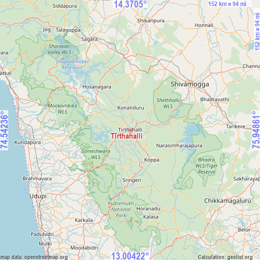
Tīrthahalli GPS coordinates[2]
13° 41' 18.06" North, 75° 14' 43.728" East
| Map corner | latitude | longitude |
|---|---|---|
| Upper-left | 14.3705°, | 74.54236° |
| Center: | 13.68835°, | 75.24548° |
| Lower-right: | 13.00422°, | 75.94861° |
| Map W x H: | 151.9×151.9 km | = 94.4×94.4mi |
| max Lat: | 34.9274° ⇑83.9% North |
| Tīrthahalli: | 13.68835° |
| min Lat: | ⇓16.1% South 8.09008° |
| min Long | Tīrthahalli | max Long |
| 68.82655° | 75.24548° | 96.81° |
| W 19.4%⇐ | ⇒80.6% E |
Elevation
Elevation of Tīrthahalli is 620 m = 2034 ft, and this is 324.4 m = 1064 ft above average elevation for this country.
| Max E: |
3681 m = 12077 ft | 10.7% |
| Tīrthahalli | 620 m 2034 ft | |
| Avg. | 295.6 m = 970 ft | |
Min E: |
1 m = 3 ft | 89.3% |
See also: India elevation on elevation.city.
Geographical zone
Tīrthahalli is located in North Torrid zone (between Equator and Tropic of Cancer). Distance of this Northern Tropic circle is 1083.9 km =673.5 mi to North.| Distance of | km | miles | from Tīrthahalli |
|---|---|---|---|
| North Pole | 8485.1 | 5272.4 | to North |
| Arctic Circle | 5879.2 | 3653.2 | to North |
| Tropic Cancer | 1083.9 | 673.5 | to North |
| Equator | 1522 | 945.7 | to South |


Nearby cities:
15 places around Tīrthahalli: (largest is in red/bold)
• Beltangadi
33.3 km =20.7 mi,  10°
10°
• Bhadrāvati
52.7 km =32.7 mi,  70°
70°
• Coondapoor
60.3 km =37.5 mi,  263°
263°
• Gangolli
62.2 km =38.6 mi,  266°
266°
• Hosanagara
31.8 km =19.8 mi,  322°
322°
• Hosangadi
31.5 km =19.6 mi, 271°
• Koppa
21.7 km =13.5 mi,  144°
144°
• Kumsi
44 km =27.3 mi,  22°
22°
• Kārkala
59.4 km =36.9 mi,  207°
207°
• Narasimharājapura
30.1 km =18.7 mi,  106°
106°
• Shimoga
44.1 km =27.4 mi,  52°
52°
• Someshwar
29.2 km =18.1 mi,  221°
221°
• Sringeri
30.2 km =18.8 mi,  178°
178°
• Sāgar
57.9 km =36 mi,  336°
336°
• Tarikere
61.4 km =38.2 mi,  87°
87°
Sources, notices
• [Note1] Compared only with cities in India existing in our database
• [Src1] Map data: © OpenStreetMap contributors (CC-BY-SA)
• [Src2] Other city data from geonames.org with taken over terms of usage.
• [Src3] Geographical zone / Annual Mean Temperature by Robert A. Rohde @ Wikipedia
