Kumsi geodata
Kumsi (Karnataka) is a populated place; located in India in Asia/Kolkata (GMT+5.5) time zone. With population of 6,468 people, there are 3254 cities with bigger population in this country. Compared to other cities in India, 83.2% of cities are located further ↑North; 79.2% of cities are located further →East and 91.5% of cities have lower elevation than Kumsi. Note1


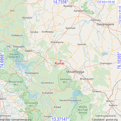
Kumsi GPS coordinates[2]
14° 3' 16.38" North, 75° 23' 59.712" East
| Map corner | latitude | longitude |
|---|---|---|
| Upper-left | 14.7356°, | 74.6968° |
| Center: | 14.05455°, | 75.39992° |
| Lower-right: | 13.37147°, | 76.10305° |
| Map W x H: | 151.7×151.7 km | = 94.3×94.3mi |
| max Lat: | 34.9274° ⇑83.2% North |
| Kumsi: | 14.05455° |
| min Lat: | ⇓16.8% South 8.09008° |
| min Long | Kumsi | max Long |
| 68.82655° | 75.39992° | 96.81° |
| W 20.8%⇐ | ⇒79.2% E |
Elevation
Elevation of Kumsi is 667 m = 2188 ft, and this is 371.4 m = 1219 ft above average elevation for this country.
| Max E: |
3681 m = 12077 ft | 8.5% |
| Kumsi | 667 m 2188 ft | |
| Avg. | 295.6 m = 970 ft | |
Min E: |
1 m = 3 ft | 91.5% |
See also: India elevation on elevation.city.
Geographical zone
Kumsi is located in North Torrid zone (between Equator and Tropic of Cancer). Distance of this Northern Tropic circle is 1043.2 km =648.2 mi to North.| Distance of | km | miles | from Kumsi |
|---|---|---|---|
| North Pole | 8444.3 | 5247 | to North |
| Arctic Circle | 5838.5 | 3627.9 | to North |
| Tropic Cancer | 1043.2 | 648.2 | to North |
| Equator | 1562.7 | 971 | to South |


Nearby cities:
15 places around Kumsi: (largest is in red/bold)
• Beltangadi
13.4 km =8.3 mi,  233°
233°
• Bhadrāvati
40.1 km =24.9 mi,  124°
124°
• Channagiri
56.8 km =35.3 mi,  93°
93°
• Hirekerūr
44.5 km =27.7 mi,  359°
359°
• Honnāli
33.5 km =20.8 mi,  52°
52°
• Hosanagara
39.4 km =24.5 mi,  246°
246°
• Koppa
58.4 km =36.3 mi,  183°
183°
• Narasimharājapura
50.8 km =31.6 mi,  166°
166°
• Nyāmti
21.7 km =13.5 mi,  61°
61°
• Shikārpur
24.4 km =15.2 mi,  348°
348°
• Shimoga
22.7 km =14.1 mi,  127°
127°
• Sorab
49.2 km =30.6 mi,  317°
317°
• Sāgar
41.8 km =26 mi,  287°
287°
• Tarikere
58.9 km =36.6 mi, 130°
• Tīrthahalli
44 km =27.3 mi,  202°
202°
Sources, notices
• [Note1] Compared only with cities in India existing in our database
• [Src1] Map data: © OpenStreetMap contributors (CC-BY-SA)
• [Src2] Other city data from geonames.org with taken over terms of usage.
• [Src3] Geographical zone / Annual Mean Temperature by Robert A. Rohde @ Wikipedia
