Shimoga geodata
Shimoga (Karnataka) is a populated place; located in India in Asia/Kolkata (GMT+5.5) time zone. With population of 319,550 people, there are 136 cities with bigger population in this country. Compared to other cities in India, 83.5% of cities are located further ↑North; 78% of cities are located further →East and 87.8% of cities have lower elevation than Shimoga. Note1


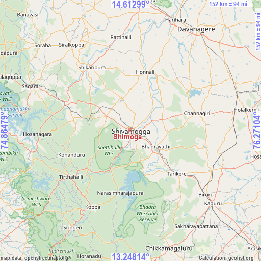
Shimoga GPS coordinates[2]
13° 55' 53.652" North, 75° 34' 4.476" East
| Map corner | latitude | longitude |
|---|---|---|
| Upper-left | 14.61299°, | 74.86479° |
| Center: | 13.93157°, | 75.56791° |
| Lower-right: | 13.24814°, | 76.27104° |
| Map W x H: | 151.8×151.8 km | = 94.3×94.3mi |
| max Lat: | 34.9274° ⇑83.5% North |
| Shimoga: | 13.93157° |
| min Lat: | ⇓16.5% South 8.09008° |
| min Long | Shimoga | max Long |
| 68.82655° | 75.56791° | 96.81° |
| W 22%⇐ | ⇒78% E |
Elevation
Elevation of Shimoga is 590 m = 1936 ft, and this is 294.4 m = 966 ft above average elevation for this country.
| Max E: |
3681 m = 12077 ft | 12.2% |
| Shimoga | 590 m 1936 ft | |
| Avg. | 295.6 m = 970 ft | |
Min E: |
1 m = 3 ft | 87.8% |
See also: Shimoga elevation on elevation.city.
Geographical zone
Shimoga is located in North Torrid zone (between Equator and Tropic of Cancer). Distance of this Northern Tropic circle is 1056.9 km =656.7 mi to North.| Distance of | km | miles | from Shimoga |
|---|---|---|---|
| North Pole | 8458 | 5255.6 | to North |
| Arctic Circle | 5852.1 | 3636.3 | to North |
| Tropic Cancer | 1056.9 | 656.7 | to North |
| Equator | 1549 | 962.5 | to South |


Nearby cities:
15 places around Shimoga: (largest is in red/bold)
• Ajjampur
52.5 km =32.6 mi,  115°
115°
• Beltangadi
29.5 km =18.3 mi,  281°
281°
• Bhadrāvati
17.4 km =10.8 mi, 121°
• Birūr
57.3 km =35.6 mi,  130°
130°
• Channagiri
40 km =24.9 mi,  75°
75°
• Hirekerūr
61.1 km =38 mi,  342°
342°
• Honnāli
35.3 km =21.9 mi,  13°
13°
• Hosanagara
54.3 km =33.7 mi,  267°
267°
• Koppa
49.8 km =30.9 mi,  206°
206°
• Kumsi
22.7 km =14.1 mi,  307°
307°
• Narasimharājapura
36.2 km =22.5 mi,  189°
189°
• Nyāmti
24.2 km =15 mi,  2°
2°
• Shikārpur
44 km =27.3 mi,  328°
328°
• Tarikere
36.3 km =22.6 mi, 132°
• Tīrthahalli
44.1 km =27.4 mi,  232°
232°
Sources, notices
• [Note1] Compared only with cities in India existing in our database
• [Src1] Map data: © OpenStreetMap contributors (CC-BY-SA)
• [Src2] Other city data from geonames.org with taken over terms of usage.
• [Src3] Geographical zone / Annual Mean Temperature by Robert A. Rohde @ Wikipedia
