Fālākāta geodata
Fālākāta (West Bengal) is a populated place; located in India in Asia/Kolkata (GMT+5.5) time zone. With population of 20,119 people, there are 2030 cities with bigger population in this country. Compared to other cities in India, 75% of cities are located further ↓South; 95.2% of cities are located further ←West and 75.6% of cities have higher elevation than Fālākāta. Note1


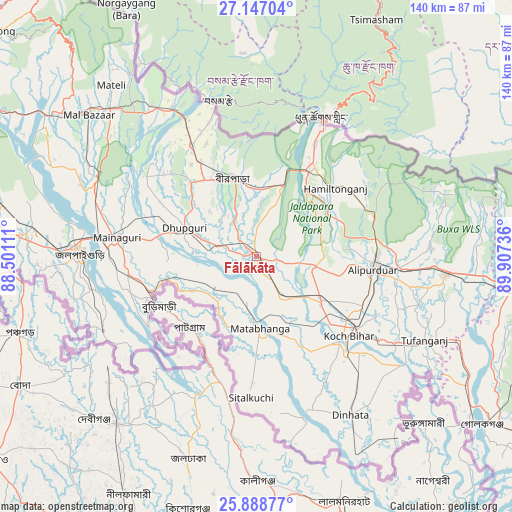
Fālākāta GPS coordinates[2]
26° 31' 10.668" North, 89° 12' 15.228" East
| Map corner | latitude | longitude |
|---|---|---|
| Upper-left | 27.14704°, | 88.50111° |
| Center: | 26.51963°, | 89.20423° |
| Lower-right: | 25.88877°, | 89.90736° |
| Map W x H: | 139.9×139.9 km | = 86.9×86.9mi |
| max Lat: | 34.9274° ⇑25% North |
| Fālākāta: | 26.51963° |
| min Lat: | ⇓75% South 8.09008° |
| min Long | Fālākāta | max Long |
| 68.82655° | 89.20423° | 96.81° |
| W 95.2%⇐ | ⇒4.8% E |
Elevation
Elevation of Fālākāta is 66 m = 217 ft, and this is 229.6 m = 753 ft below average elevation for this country.
| Max E: |
3681 m = 12077 ft | 75.6% |
| Avg. | 295.6 m = 970 ft | |
| Fālākāta | 66 m = 217 ft | |
Min E: |
1 m = 3 ft | 24.4% |
See also: India elevation on elevation.city.
Geographical zone
Fālākāta is located in North temperate zone (between Tropic of Cancer and the Arctic Circle). Distance of this Northern Tropic circle is 342.8 km =213 mi to South.| Distance of | km | miles | from Fālākāta |
|---|---|---|---|
| North Pole | 7058.4 | 4385.9 | to North |
| Arctic Circle | 4452.5 | 2766.7 | to North |
| Tropic Cancer | 342.8 | 213 | to South |
| Equator | 2948.7 | 1832.2 | to South |


Nearby cities:
15 places around Fālākāta: (largest is in red/bold)
• Alīpur Duār
32 km =19.9 mi,  97°
97°
• Birpara
21.3 km =13.2 mi,  344°
344°
• Dhupgāri
21.1 km =13.1 mi,  291°
291°
• Dīnhāta
49.8 km =30.9 mi,  149°
149°
• Goyerkāta
26.8 km =16.7 mi,  318°
318°
• Haldībāri
46.6 km =29 mi,  244°
244°
• Hāsimāra
29.3 km =18.2 mi,  30°
30°
• Jaigaon
40.3 km =25 mi, 25°
• Jalpāiguri
46.9 km =29.1 mi,  269°
269°
• Koch Bihār
32.3 km =20.1 mi,  132°
132°
• Latabāri
69.3 km =43.1 mi,  110°
110°
• Maināguri
38.5 km =23.9 mi,  277°
277°
• Mātābhānga
19.8 km =12.3 mi,  176°
176°
• Odlābāri
67.1 km =41.7 mi,  301°
301°
• Tufānganj
51.2 km =31.8 mi,  116°
116°
Sources, notices
• [Note1] Compared only with cities in India existing in our database
• [Src1] Map data: © OpenStreetMap contributors (CC-BY-SA)
• [Src2] Other city data from geonames.org with taken over terms of usage.
• [Src3] Geographical zone / Annual Mean Temperature by Robert A. Rohde @ Wikipedia
