Alūr geodata
Alūr (Karnataka) is a populated place; located in India in Asia/Kolkata (GMT+5.5) time zone. With population of 6,604 people, there are 3241 cities with bigger population in this country. Compared to other cities in India, 86.4% of cities are located further ↑North; 73.7% of cities are located further →East and 96% of cities have lower elevation than Alūr. Note1


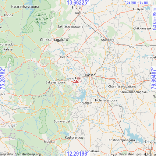
Alūr GPS coordinates[2]
12° 58' 40.98" North, 75° 59' 27.384" East
| Map corner | latitude | longitude |
|---|---|---|
| Upper-left | 13.66225°, | 75.28782° |
| Center: | 12.97805°, | 75.99094° |
| Lower-right: | 12.29196°, | 76.69407° |
| Map W x H: | 152.4×152.4 km | = 94.7×94.7mi |
| max Lat: | 34.9274° ⇑86.4% North |
| Alūr: | 12.97805° |
| min Lat: | ⇓13.6% South 8.09008° |
| min Long | Alūr | max Long |
| 68.82655° | 75.99094° | 96.81° |
| W 26.3%⇐ | ⇒73.7% E |
Elevation
Elevation of Alūr is 975 m = 3199 ft, and this is 679.4 m = 2229 ft above average elevation for this country.
| Max E: |
3681 m = 12077 ft | 4% |
| Alūr | 975 m 3199 ft | |
| Avg. | 295.6 m = 970 ft | |
Min E: |
1 m = 3 ft | 96% |
See also: India elevation on elevation.city.
Geographical zone
Alūr is located in North Torrid zone (between Equator and Tropic of Cancer). Distance of this Northern Tropic circle is 1162.9 km =722.6 mi to North.| Distance of | km | miles | from Alūr |
|---|---|---|---|
| North Pole | 8564 | 5321.4 | to North |
| Arctic Circle | 5958.2 | 3702.3 | to North |
| Tropic Cancer | 1162.9 | 722.6 | to North |
| Equator | 1443 | 896.6 | to South |


Nearby cities:
15 places around Alūr: (largest is in red/bold)
• Arkalgūd
25.2 km =15.7 mi,  162°
162°
• Arsikere
47.2 km =29.3 mi,  37°
37°
• Belūr
24.9 km =15.5 mi,  326°
326°
• Bānāvar
51.5 km =32 mi,  21°
21°
• Channarāyapatna
43.7 km =27.2 mi,  100°
100°
• Chikmagalūr
44.9 km =27.9 mi, 328°
• Gorūr
19 km =11.8 mi, 155°
• Hassan
11.9 km =7.4 mi,  74°
74°
• Hole Narsipur
34.7 km =21.6 mi,  127°
127°
• Kodlipet
22.7 km =14.1 mi,  209°
209°
• Konanūr
39.2 km =24.4 mi,  170°
170°
• Mudgere
41.6 km =25.8 mi,  294°
294°
• Sakleshpur
22.7 km =14.1 mi,  259°
259°
• Sanivārsante
30 km =18.6 mi,  202°
202°
• Somvārpet
45.1 km =28 mi, 199°
Sources, notices
• [Note1] Compared only with cities in India existing in our database
• [Src1] Map data: © OpenStreetMap contributors (CC-BY-SA)
• [Src2] Other city data from geonames.org with taken over terms of usage.
• [Src3] Geographical zone / Annual Mean Temperature by Robert A. Rohde @ Wikipedia
