Hassan geodata
Hassan (Karnataka) is a populated place; located in India in Asia/Kolkata (GMT+5.5) time zone. With population of 128,531 people, there are 339 cities with bigger population in this country. Compared to other cities in India, 86.2% of cities are located further ↑North; 72.6% of cities are located further →East and 95.9% of cities have lower elevation than Hassan. Note1


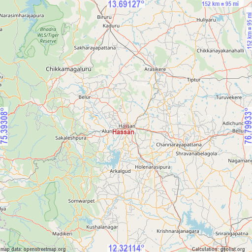
Hassan GPS coordinates[2]
13° 0' 25.74" North, 76° 5' 46.32" East
| Map corner | latitude | longitude |
|---|---|---|
| Upper-left | 13.69127°, | 75.39308° |
| Center: | 13.00715°, | 76.0962° |
| Lower-right: | 12.32114°, | 76.79933° |
| Map W x H: | 152.3×152.3 km | = 94.6×94.6mi |
| max Lat: | 34.9274° ⇑86.2% North |
| Hassan: | 13.00715° |
| min Lat: | ⇓13.8% South 8.09008° |
| min Long | Hassan | max Long |
| 68.82655° | 76.0962° | 96.81° |
| W 27.4%⇐ | ⇒72.6% E |
Elevation
Elevation of Hassan is 955 m = 3133 ft, and this is 659.4 m = 2163 ft above average elevation for this country.
| Max E: |
3681 m = 12077 ft | 4.1% |
| Hassan | 955 m 3133 ft | |
| Avg. | 295.6 m = 970 ft | |
Min E: |
1 m = 3 ft | 95.9% |
See also: Hassan elevation on elevation.city.
Geographical zone
Hassan is located in North Torrid zone (between Equator and Tropic of Cancer). Distance of this Northern Tropic circle is 1159.7 km =720.6 mi to North.| Distance of | km | miles | from Hassan |
|---|---|---|---|
| North Pole | 8560.8 | 5319.4 | to North |
| Arctic Circle | 5954.9 | 3700.2 | to North |
| Tropic Cancer | 1159.7 | 720.6 | to North |
| Equator | 1446.3 | 898.7 | to South |


Nearby cities:
15 places around Hassan: (largest is in red/bold)
• Alūr
11.9 km =7.4 mi,  254°
254°
• Arkalgūd
27.6 km =17.1 mi,  188°
188°
• Arsikere
38.4 km =23.9 mi,  27°
27°
• Belūr
30.6 km =19 mi,  305°
305°
• Bānāvar
45.4 km =28.2 mi,  9°
9°
• Channarāyapatna
33.5 km =20.8 mi,  109°
109°
• Chikmagalūr
49.4 km =30.7 mi,  315°
315°
• Gorūr
20.8 km =12.9 mi, 189°
• Hole Narsipur
29.3 km =18.2 mi,  146°
146°
• Kodlipet
32.3 km =20.1 mi,  224°
224°
• Konanūr
42.2 km =26.2 mi, 186°
• Sakleshpur
34.5 km =21.4 mi,  257°
257°
• Sanivārsante
38.4 km =23.9 mi, 216°
• Srāvana Belgola
45.7 km =28.4 mi, 111°
• Tiptūr
49.7 km =30.9 mi,  56°
56°
Sources, notices
• [Note1] Compared only with cities in India existing in our database
• [Src1] Map data: © OpenStreetMap contributors (CC-BY-SA)
• [Src2] Other city data from geonames.org with taken over terms of usage.
• [Src3] Geographical zone / Annual Mean Temperature by Robert A. Rohde @ Wikipedia
