Srāvana Belgola geodata
Srāvana Belgola (Karnataka) is a populated place; located in India in Asia/Kolkata (GMT+5.5) time zone. With population of 5,079 people, there are 3338 cities with bigger population in this country. Compared to other cities in India, 87.2% of cities are located further ↑North; 68.6% of cities are located further →East and 94.9% of cities have lower elevation than Srāvana Belgola. Note1


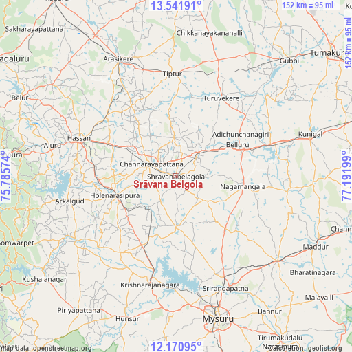
Srāvana Belgola GPS coordinates[2]
12° 51' 26.532" North, 76° 29' 19.896" East
| Map corner | latitude | longitude |
|---|---|---|
| Upper-left | 13.54191°, | 75.78574° |
| Center: | 12.85737°, | 76.48886° |
| Lower-right: | 12.17095°, | 77.19199° |
| Map W x H: | 152.4×152.4 km | = 94.7×94.7mi |
| max Lat: | 34.9274° ⇑87.2% North |
| Srāvana Belgola: | 12.85737° |
| min Lat: | ⇓12.8% South 8.09008° |
| min Long | Srāvana Belgol | max Long |
| 68.82655° | 76.48886° | 96.81° |
| W 31.4%⇐ | ⇒68.6% E |
Elevation
Elevation of Srāvana Belgola is 878 m = 2881 ft, and this is 582.4 m = 1911 ft above average elevation for this country.
| Max E: |
3681 m = 12077 ft | 5.1% |
| Srāvana Belgola | 878 m 2881 ft | |
| Avg. | 295.6 m = 970 ft | |
Min E: |
1 m = 3 ft | 94.9% |
See also: India elevation on elevation.city.
Geographical zone
Srāvana Belgola is located in North Torrid zone (between Equator and Tropic of Cancer). Distance of this Northern Tropic circle is 1176.3 km =730.9 mi to North.| Distance of | km | miles | from Srāvana Belgola |
|---|---|---|---|
| North Pole | 8577.5 | 5329.8 | to North |
| Arctic Circle | 5971.6 | 3710.6 | to North |
| Tropic Cancer | 1176.3 | 730.9 | to North |
| Equator | 1429.6 | 888.3 | to South |


Nearby cities:
15 places around Srāvana Belgola: (largest is in red/bold)
• Alūr
55.6 km =34.5 mi,  283°
283°
• Arkalgūd
47.7 km =29.6 mi,  257°
257°
• Bellūru
29.8 km =18.5 mi,  62°
62°
• Channarāyapatna
12.2 km =7.6 mi,  296°
296°
• French Rocks
44.4 km =27.6 mi,  153°
153°
• Gorūr
46.1 km =28.6 mi,  265°
265°
• Hassan
45.7 km =28.4 mi,  291°
291°
• Hole Narsipur
27.8 km =17.3 mi,  253°
253°
• Konanūr
53.8 km =33.4 mi,  242°
242°
• Krishnarājpet
21.3 km =13.2 mi,  180°
180°
• Melukote
27.7 km =17.2 mi,  141°
141°
• Nāgamangala
29.1 km =18.1 mi,  98°
98°
• Shrīrangapattana
52.8 km =32.8 mi,  156°
156°
• Tiptūr
44.4 km =27.6 mi,  358°
358°
• Turuvekere
39.1 km =24.3 mi,  29°
29°
Sources, notices
• [Note1] Compared only with cities in India existing in our database
• [Src1] Map data: © OpenStreetMap contributors (CC-BY-SA)
• [Src2] Other city data from geonames.org with taken over terms of usage.
• [Src3] Geographical zone / Annual Mean Temperature by Robert A. Rohde @ Wikipedia
