Baldev geodata
Baldev (Uttar Pradesh) is a populated place; located in India in Asia/Kolkata (GMT+5.5) time zone. With population of 10,536 people, there are 2887 cities with bigger population in this country. Compared to other cities in India, 81.3% of cities are located further ↓South; 53.4% of cities are located further →East and 54.3% of cities have higher elevation than Baldev. Note1


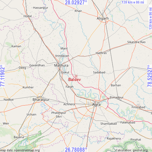
Baldev GPS coordinates[2]
27° 24' 24.624" North, 77° 49' 19.704" East
| Map corner | latitude | longitude |
|---|---|---|
| Upper-left | 28.02927°, | 77.11902° |
| Center: | 27.40684°, | 77.82214° |
| Lower-right: | 26.78088°, | 78.52527° |
| Map W x H: | 138.8×138.8 km | = 86.2×86.2mi |
| max Lat: | 34.9274° ⇑18.7% North |
| Baldev: | 27.40684° |
| min Lat: | ⇓81.3% South 8.09008° |
| min Long | Baldev | max Long |
| 68.82655° | 77.82214° | 96.81° |
| W 46.6%⇐ | ⇒53.4% E |
Elevation
Elevation of Baldev is 179 m = 587 ft, and this is 116.6 m = 383 ft below average elevation for this country.
| Max E: |
3681 m = 12077 ft | 54.3% |
| Avg. | 295.6 m = 970 ft | |
| Baldev | 179 m = 587 ft | |
Min E: |
1 m = 3 ft | 45.7% |
See also: India elevation on elevation.city.
Geographical zone
Baldev is located in North temperate zone (between Tropic of Cancer and the Arctic Circle). Distance of this Northern Tropic circle is 441.4 km =274.3 mi to South.| Distance of | km | miles | from Baldev |
|---|---|---|---|
| North Pole | 6959.7 | 4324.6 | to North |
| Arctic Circle | 4353.8 | 2705.3 | to North |
| Tropic Cancer | 441.4 | 274.3 | to South |
| Equator | 3047.4 | 1893.6 | to South |


Nearby cities:
15 places around Baldev: (largest is in red/bold)
• Achhnera
26.2 km =16.3 mi,  194°
194°
• Agra
31.4 km =19.5 mi,  142°
142°
• Beswān
26.3 km =16.3 mi,  12°
12°
• Dayāl Bāgh
27.8 km =17.3 mi, 137°
• Farah
11.3 km =7 mi,  211°
211°
• Gokul
10.7 km =6.6 mi,  289°
289°
• Hāthras
30.9 km =19.2 mi,  47°
47°
• Kiraoli
30.2 km =18.8 mi, 186°
• Mahāban
8.3 km =5.2 mi, 290°
• Mathura
18.3 km =11.4 mi,  305°
305°
• Mursān
22.3 km =13.9 mi,  31°
31°
• Rādhākund
35.2 km =21.9 mi, 291°
• Rāya
16.9 km =10.5 mi,  349°
349°
• Sadābād
21.5 km =13.4 mi,  80°
80°
• Vrindāvan
23 km =14.3 mi,  327°
327°
Sources, notices
• [Note1] Compared only with cities in India existing in our database
• [Src1] Map data: © OpenStreetMap contributors (CC-BY-SA)
• [Src2] Other city data from geonames.org with taken over terms of usage.
• [Src3] Geographical zone / Annual Mean Temperature by Robert A. Rohde @ Wikipedia
