Hāthras geodata
Hāthras (Uttar Pradesh) is a populated place; located in India in Asia/Kolkata (GMT+5.5) time zone. With population of 126,882 people, there are 347 cities with bigger population in this country. Compared to other cities in India, 82.6% of cities are located further ↓South; 50.8% of cities are located further →East and 52.8% of cities have higher elevation than Hāthras. Note1


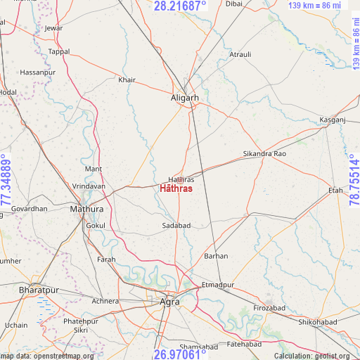
Hāthras GPS coordinates[2]
27° 35' 43.836" North, 78° 3' 7.236" East
| Map corner | latitude | longitude |
|---|---|---|
| Upper-left | 28.21687°, | 77.34889° |
| Center: | 27.59551°, | 78.05201° |
| Lower-right: | 26.97061°, | 78.75514° |
| Map W x H: | 138.6×138.6 km | = 86.1×86.1mi |
| max Lat: | 34.9274° ⇑17.4% North |
| Hāthras: | 27.59551° |
| min Lat: | ⇓82.6% South 8.09008° |
| min Long | Hāthras | max Long |
| 68.82655° | 78.05201° | 96.81° |
| W 49.2%⇐ | ⇒50.8% E |
Elevation
Elevation of Hāthras is 185 m = 607 ft, and this is 110.6 m = 363 ft below average elevation for this country.
| Max E: |
3681 m = 12077 ft | 52.8% |
| Avg. | 295.6 m = 970 ft | |
| Hāthras | 185 m = 607 ft | |
Min E: |
1 m = 3 ft | 47.2% |
See also: Hāthras elevation on elevation.city.
Geographical zone
Hāthras is located in North temperate zone (between Tropic of Cancer and the Arctic Circle). Distance of this Northern Tropic circle is 462.4 km =287.3 mi to South.| Distance of | km | miles | from Hāthras |
|---|---|---|---|
| North Pole | 6938.7 | 4311.5 | to North |
| Arctic Circle | 4332.8 | 2692.3 | to North |
| Tropic Cancer | 462.4 | 287.3 | to South |
| Equator | 3068.3 | 1906.6 | to South |


Nearby cities:
15 places around Hāthras: (largest is in red/bold)
• Alīgarh
31.9 km =19.8 mi,  4°
4°
• Baldev
30.9 km =19.2 mi,  227°
227°
• Beswān
17.6 km =10.9 mi,  285°
285°
• Gokul
37 km =23 mi,  242°
242°
• Iglās
17 km =10.6 mi,  319°
319°
• Jalesar
28.2 km =17.5 mi,  118°
118°
• Jalālī
36.1 km =22.4 mi,  33°
33°
• Mahāban
35.4 km =22 mi, 239°
• Mathura
38.8 km =24.1 mi,  254°
254°
• Mursān
11.1 km =6.9 mi,  259°
259°
• Rāya
26.2 km =16.3 mi, 260°
• Sadābād
17.6 km =10.9 mi,  184°
184°
• Sikandra Rao
33.9 km =21.1 mi,  72°
72°
• Sāsni
12.3 km =7.6 mi,  14°
14°
• Vrindāvan
35.1 km =21.8 mi,  267°
267°
Sources, notices
• [Note1] Compared only with cities in India existing in our database
• [Src1] Map data: © OpenStreetMap contributors (CC-BY-SA)
• [Src2] Other city data from geonames.org with taken over terms of usage.
• [Src3] Geographical zone / Annual Mean Temperature by Robert A. Rohde @ Wikipedia
