Mursān geodata
Mursān (Uttar Pradesh) is a populated place; located in India in Asia/Kolkata (GMT+5.5) time zone. With population of 12,310 people, there are 2719 cities with bigger population in this country. Compared to other cities in India, 82.5% of cities are located further ↓South; 51.8% of cities are located further →East and 54% of cities have higher elevation than Mursān. Note1


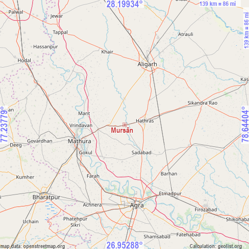
Mursān GPS coordinates[2]
27° 34' 40.368" North, 77° 56' 27.276" East
| Map corner | latitude | longitude |
|---|---|---|
| Upper-left | 28.19934°, | 77.23779° |
| Center: | 27.57788°, | 77.94091° |
| Lower-right: | 26.95288°, | 78.64404° |
| Map W x H: | 138.6×138.6 km | = 86.1×86.1mi |
| max Lat: | 34.9274° ⇑17.5% North |
| Mursān: | 27.57788° |
| min Lat: | ⇓82.5% South 8.09008° |
| min Long | Mursān | max Long |
| 68.82655° | 77.94091° | 96.81° |
| W 48.2%⇐ | ⇒51.8% E |
Elevation
Elevation of Mursān is 180 m = 591 ft, and this is 115.6 m = 379 ft below average elevation for this country.
| Max E: |
3681 m = 12077 ft | 54% |
| Avg. | 295.6 m = 970 ft | |
| Mursān | 180 m = 591 ft | |
Min E: |
1 m = 3 ft | 46% |
See also: India elevation on elevation.city.
Geographical zone
Mursān is located in North temperate zone (between Tropic of Cancer and the Arctic Circle). Distance of this Northern Tropic circle is 460.5 km =286.1 mi to South.| Distance of | km | miles | from Mursān |
|---|---|---|---|
| North Pole | 6940.7 | 4312.7 | to North |
| Arctic Circle | 4334.8 | 2693.5 | to North |
| Tropic Cancer | 460.5 | 286.1 | to South |
| Equator | 3066.4 | 1905.4 | to South |


Nearby cities:
15 places around Mursān: (largest is in red/bold)
• Alīgarh
36.2 km =22.5 mi,  21°
21°
• Baldev
22.3 km =13.9 mi,  211°
211°
• Beswān
9 km =5.6 mi,  318°
318°
• Dayāl Bāgh
40.3 km =25 mi,  170°
170°
• Farah
33.6 km =20.9 mi, 211°
• Gokul
26.7 km =16.6 mi,  234°
234°
• Hāthras
11.1 km =6.9 mi,  79°
79°
• Iglās
14.8 km =9.2 mi,  359°
359°
• Jalesar
37.6 km =23.4 mi,  108°
108°
• Mahāban
25.3 km =15.7 mi, 230°
• Mathura
27.8 km =17.3 mi,  252°
252°
• Rāya
15.1 km =9.4 mi,  260°
260°
• Sadābād
18.2 km =11.3 mi,  148°
148°
• Sāsni
19.7 km =12.2 mi,  45°
45°
• Vrindāvan
24.1 km =15 mi,  270°
270°
Sources, notices
• [Note1] Compared only with cities in India existing in our database
• [Src1] Map data: © OpenStreetMap contributors (CC-BY-SA)
• [Src2] Other city data from geonames.org with taken over terms of usage.
• [Src3] Geographical zone / Annual Mean Temperature by Robert A. Rohde @ Wikipedia
