Sadābād geodata
Sadābād (Uttar Pradesh) is a populated place; located in India in Asia/Kolkata (GMT+5.5) time zone. With population of 36,093 people, there are 1207 cities with bigger population in this country. Compared to other cities in India, 81.5% of cities are located further ↓South; 51% of cities are located further →East and 55.8% of cities have higher elevation than Sadābād. Note1


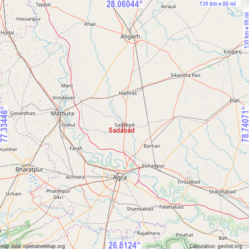
Sadābād GPS coordinates[2]
27° 26' 17.448" North, 78° 2' 15.288" East
| Map corner | latitude | longitude |
|---|---|---|
| Upper-left | 28.06044°, | 77.33446° |
| Center: | 27.43818°, | 78.03758° |
| Lower-right: | 26.8124°, | 78.74071° |
| Map W x H: | 138.8×138.8 km | = 86.2×86.2mi |
| max Lat: | 34.9274° ⇑18.5% North |
| Sadābād: | 27.43818° |
| min Lat: | ⇓81.5% South 8.09008° |
| min Long | Sadābād | max Long |
| 68.82655° | 78.03758° | 96.81° |
| W 49%⇐ | ⇒51% E |
Elevation
Elevation of Sadābād is 171 m = 561 ft, and this is 124.6 m = 409 ft below average elevation for this country.
| Max E: |
3681 m = 12077 ft | 55.8% |
| Avg. | 295.6 m = 970 ft | |
| Sadābād | 171 m = 561 ft | |
Min E: |
1 m = 3 ft | 44.2% |
See also: India elevation on elevation.city.
Geographical zone
Sadābād is located in North temperate zone (between Tropic of Cancer and the Arctic Circle). Distance of this Northern Tropic circle is 444.9 km =276.4 mi to South.| Distance of | km | miles | from Sadābād |
|---|---|---|---|
| North Pole | 6956.2 | 4322.4 | to North |
| Arctic Circle | 4350.3 | 2703.2 | to North |
| Tropic Cancer | 444.9 | 276.4 | to South |
| Equator | 3050.8 | 1895.7 | to South |


Nearby cities:
15 places around Sadābād: (largest is in red/bold)
• Agra
28.4 km =17.6 mi,  184°
184°
• Baldev
21.5 km =13.4 mi,  260°
260°
• Beswān
27.1 km =16.8 mi,  325°
325°
• Dayāl Bāgh
24.3 km =15.1 mi,  186°
186°
• Farah
30.2 km =18.8 mi,  244°
244°
• Gokul
31.3 km =19.4 mi,  270°
270°
• Hāthras
17.6 km =10.9 mi,  4°
4°
• Iglās
31.8 km =19.8 mi,  342°
342°
• Itimādpur
27.6 km =17.1 mi,  144°
144°
• Jalesar
26.5 km =16.5 mi,  81°
81°
• Mahāban
29 km =18 mi, 268°
• Mursān
18.2 km =11.3 mi, 328°
• Rāya
27.7 km =17.2 mi,  298°
298°
• Sāsni
29.8 km =18.5 mi,  8°
8°
• Tūndla
31.7 km =19.7 mi, 141°
Sources, notices
• [Note1] Compared only with cities in India existing in our database
• [Src1] Map data: © OpenStreetMap contributors (CC-BY-SA)
• [Src2] Other city data from geonames.org with taken over terms of usage.
• [Src3] Geographical zone / Annual Mean Temperature by Robert A. Rohde @ Wikipedia
