Goribidnūr geodata
Goribidnūr (Karnataka) is a populated place; located in India in Asia/Kolkata (GMT+5.5) time zone. With population of 32,447 people, there are 1341 cities with bigger population in this country. Compared to other cities in India, 84.2% of cities are located further ↑North; 57.1% of cities are located further →East and 92.2% of cities have lower elevation than Goribidnūr. Note1


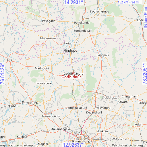
Goribidnūr GPS coordinates[2]
13° 36' 38.592" North, 77° 31' 2.568" East
| Map corner | latitude | longitude |
|---|---|---|
| Upper-left | 14.2931°, | 76.81426° |
| Center: | 13.61072°, | 77.51738° |
| Lower-right: | 12.92637°, | 78.22051° |
| Map W x H: | 152×152 km | = 94.4×94.4mi |
| max Lat: | 34.9274° ⇑84.2% North |
| Goribidnūr: | 13.61072° |
| min Lat: | ⇓15.8% South 8.09008° |
| min Long | Goribidnūr | max Long |
| 68.82655° | 77.51738° | 96.81° |
| W 42.9%⇐ | ⇒57.1% E |
Elevation
Elevation of Goribidnūr is 690 m = 2264 ft, and this is 394.4 m = 1294 ft above average elevation for this country.
| Max E: |
3681 m = 12077 ft | 7.8% |
| Goribidnūr | 690 m 2264 ft | |
| Avg. | 295.6 m = 970 ft | |
Min E: |
1 m = 3 ft | 92.2% |
See also: India elevation on elevation.city.
Geographical zone
Goribidnūr is located in North Torrid zone (between Equator and Tropic of Cancer). Distance of this Northern Tropic circle is 1092.5 km =678.8 mi to North.| Distance of | km | miles | from Goribidnūr |
|---|---|---|---|
| North Pole | 8493.7 | 5277.7 | to North |
| Arctic Circle | 5887.8 | 3658.5 | to North |
| Tropic Cancer | 1092.5 | 678.8 | to North |
| Equator | 1513.4 | 940.4 | to South |


Nearby cities:
15 places around Goribidnūr: (largest is in red/bold)
• Bāgepalli
35.8 km =22.2 mi,  57°
57°
• Chik Ballāpur
30 km =18.6 mi,  130°
130°
• Devanhalli
45.6 km =28.3 mi,  152°
152°
• Dod Ballāpur
35.2 km =21.9 mi,  176°
176°
• Gorantla
49.8 km =30.9 mi,  33°
33°
• Gudibanda
21.3 km =13.2 mi,  71°
71°
• Hindupur
24.3 km =15.1 mi,  353°
353°
• Kodigenahalli
18.8 km =11.7 mi,  310°
310°
• Koratagere
31.8 km =19.8 mi,  251°
251°
• Maddagiri
33.4 km =20.8 mi,  279°
279°
• Penukonda
53.2 km =33.1 mi,  9°
9°
• Sidlaghatta
44.9 km =27.9 mi,  123°
123°
• Tumkūr
54 km =33.6 mi,  236°
236°
• Vadigenhalli
46.5 km =28.9 mi,  138°
138°
• Yelahanka
57.3 km =35.6 mi,  171°
171°
Sources, notices
• [Note1] Compared only with cities in India existing in our database
• [Src1] Map data: © OpenStreetMap contributors (CC-BY-SA)
• [Src2] Other city data from geonames.org with taken over terms of usage.
• [Src3] Geographical zone / Annual Mean Temperature by Robert A. Rohde @ Wikipedia
