Gudibanda geodata
Gudibanda (Karnataka) is a populated place; located in India in Asia/Kolkata (GMT+5.5) time zone. With population of 9,255 people, there are 3015 cities with bigger population in this country. Compared to other cities in India, 83.9% of cities are located further ↑North; 55% of cities are located further →East and 94.4% of cities have lower elevation than Gudibanda. Note1


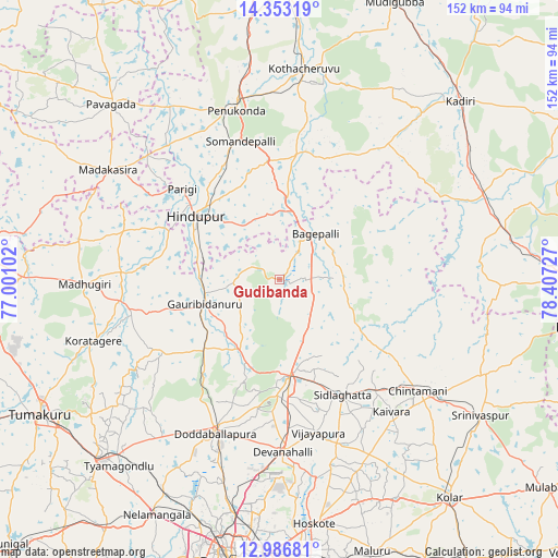
Gudibanda GPS coordinates[2]
13° 40' 15.564" North, 77° 42' 14.904" East
| Map corner | latitude | longitude |
|---|---|---|
| Upper-left | 14.35319°, | 77.00102° |
| Center: | 13.67099°, | 77.70414° |
| Lower-right: | 12.98681°, | 78.40727° |
| Map W x H: | 151.9×151.9 km | = 94.4×94.4mi |
| max Lat: | 34.9274° ⇑83.9% North |
| Gudibanda: | 13.67099° |
| min Lat: | ⇓16.1% South 8.09008° |
| min Long | Gudibanda | max Long |
| 68.82655° | 77.70414° | 96.81° |
| W 45%⇐ | ⇒55% E |
Elevation
Elevation of Gudibanda is 832 m = 2730 ft, and this is 536.4 m = 1760 ft above average elevation for this country.
| Max E: |
3681 m = 12077 ft | 5.6% |
| Gudibanda | 832 m 2730 ft | |
| Avg. | 295.6 m = 970 ft | |
Min E: |
1 m = 3 ft | 94.4% |
See also: India elevation on elevation.city.
Geographical zone
Gudibanda is located in North Torrid zone (between Equator and Tropic of Cancer). Distance of this Northern Tropic circle is 1085.8 km =674.7 mi to North.| Distance of | km | miles | from Gudibanda |
|---|---|---|---|
| North Pole | 8487 | 5273.6 | to North |
| Arctic Circle | 5881.1 | 3654.3 | to North |
| Tropic Cancer | 1085.8 | 674.7 | to North |
| Equator | 1520.1 | 944.5 | to South |


Nearby cities:
15 places around Gudibanda: (largest is in red/bold)
• Bāgepalli
16 km =9.9 mi,  38°
38°
• Chik Ballāpur
26.4 km =16.4 mi,  174°
174°
• Chintāmani
48.1 km =29.9 mi,  128°
128°
• Devanhalli
47.2 km =29.3 mi,  178°
178°
• Dod Ballāpur
45.6 km =28.3 mi,  203°
203°
• Gorantla
35.6 km =22.1 mi,  11°
11°
• Goribidnūr
21.3 km =13.2 mi,  251°
251°
• Hindupur
28.9 km =18 mi,  307°
307°
• Kodigenahalli
34.8 km =21.6 mi,  279°
279°
• Koratagere
53.1 km =33 mi, 251°
• Maddagiri
53.1 km =33 mi,  268°
268°
• Penukonda
47.3 km =29.4 mi,  345°
345°
• Puttaparthi
56.2 km =34.9 mi, 11°
• Sidlaghatta
35.8 km =22.2 mi,  151°
151°
• Vadigenhalli
42.9 km =26.7 mi, 165°
Sources, notices
• [Note1] Compared only with cities in India existing in our database
• [Src1] Map data: © OpenStreetMap contributors (CC-BY-SA)
• [Src2] Other city data from geonames.org with taken over terms of usage.
• [Src3] Geographical zone / Annual Mean Temperature by Robert A. Rohde @ Wikipedia
