Hindupur geodata
Hindupur (Andhra Pradesh) is a populated place; located in India in Asia/Kolkata (GMT+5.5) time zone. With population of 133,298 people, there are 327 cities with bigger population in this country. Compared to other cities in India, 83.6% of cities are located further ↑North; 57.4% of cities are located further →East and 89.7% of cities have lower elevation than Hindupur. Note1


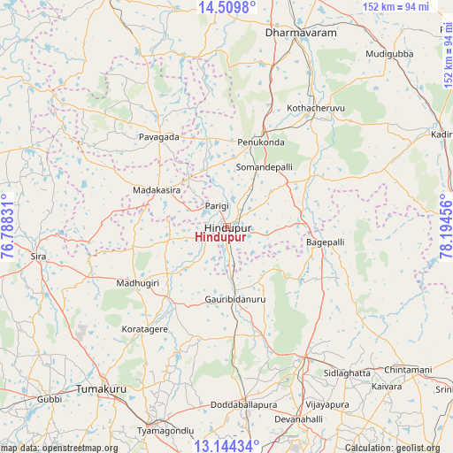
Hindupur GPS coordinates[2]
13° 49' 41.052" North, 77° 29' 29.148" East
| Map corner | latitude | longitude |
|---|---|---|
| Upper-left | 14.5098°, | 76.78831° |
| Center: | 13.82807°, | 77.49143° |
| Lower-right: | 13.14434°, | 78.19456° |
| Map W x H: | 151.8×151.8 km | = 94.3×94.3mi |
| max Lat: | 34.9274° ⇑83.6% North |
| Hindupur: | 13.82807° |
| min Lat: | ⇓16.4% South 8.09008° |
| min Long | Hindupur | max Long |
| 68.82655° | 77.49143° | 96.81° |
| W 42.6%⇐ | ⇒57.4% E |
Elevation
Elevation of Hindupur is 630 m = 2067 ft, and this is 334.4 m = 1097 ft above average elevation for this country.
| Max E: |
3681 m = 12077 ft | 10.3% |
| Hindupur | 630 m 2067 ft | |
| Avg. | 295.6 m = 970 ft | |
Min E: |
1 m = 3 ft | 89.7% |
See also: Hindupur elevation on elevation.city.
Geographical zone
Hindupur is located in North Torrid zone (between Equator and Tropic of Cancer). Distance of this Northern Tropic circle is 1068.4 km =663.9 mi to North.| Distance of | km | miles | from Hindupur |
|---|---|---|---|
| North Pole | 8469.5 | 5262.7 | to North |
| Arctic Circle | 5863.6 | 3643.5 | to North |
| Tropic Cancer | 1068.4 | 663.9 | to North |
| Equator | 1537.5 | 955.4 | to South |


Nearby cities:
15 places around Hindupur: (largest is in red/bold)
• Bāgepalli
33.3 km =20.7 mi,  98°
98°
• Chik Ballāpur
50.6 km =31.4 mi,  149°
149°
• Dod Ballāpur
59.5 km =37 mi,  175°
175°
• Gorantla
34.9 km =21.7 mi,  60°
60°
• Goribidnūr
24.3 km =15.1 mi,  173°
173°
• Gudibanda
28.9 km =18 mi,  127°
127°
• Hosakote
60.8 km =37.8 mi,  325°
325°
• Kodigenahalli
16.4 km =10.2 mi,  223°
223°
• Koratagere
43.7 km =27.2 mi, 218°
• Maddagiri
35.4 km =22 mi,  238°
238°
• Penukonda
30.4 km =18.9 mi,  21°
21°
• Puttaparthi
51 km =31.7 mi,  42°
42°
• Pāvugada
37.8 km =23.5 mi,  322°
322°
• Sidlaghatta
63.3 km =39.3 mi,  140°
140°
• Sīra
64.1 km =39.8 mi,  261°
261°
Sources, notices
• [Note1] Compared only with cities in India existing in our database
• [Src1] Map data: © OpenStreetMap contributors (CC-BY-SA)
• [Src2] Other city data from geonames.org with taken over terms of usage.
• [Src3] Geographical zone / Annual Mean Temperature by Robert A. Rohde @ Wikipedia
