Koratagere geodata
Koratagere (Karnataka) is a populated place; located in India in Asia/Kolkata (GMT+5.5) time zone. With population of 14,445 people, there are 2516 cities with bigger population in this country. Compared to other cities in India, 84.3% of cities are located further ↑North; 60.7% of cities are located further →East and 93.2% of cities have lower elevation than Koratagere. Note1


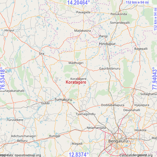
Koratagere GPS coordinates[2]
13° 31' 19.2" North, 77° 14' 14.28" East
| Map corner | latitude | longitude |
|---|---|---|
| Upper-left | 14.20464°, | 76.53418° |
| Center: | 13.522°, | 77.2373° |
| Lower-right: | 12.8374°, | 77.94043° |
| Map W x H: | 152×152 km | = 94.4×94.4mi |
| max Lat: | 34.9274° ⇑84.3% North |
| Koratagere: | 13.522° |
| min Lat: | ⇓15.7% South 8.09008° |
| min Long | Koratagere | max Long |
| 68.82655° | 77.2373° | 96.81° |
| W 39.3%⇐ | ⇒60.7% E |
Elevation
Elevation of Koratagere is 763 m = 2503 ft, and this is 467.4 m = 1533 ft above average elevation for this country.
| Max E: |
3681 m = 12077 ft | 6.8% |
| Koratagere | 763 m 2503 ft | |
| Avg. | 295.6 m = 970 ft | |
Min E: |
1 m = 3 ft | 93.2% |
See also: India elevation on elevation.city.
Geographical zone
Koratagere is located in North Torrid zone (between Equator and Tropic of Cancer). Distance of this Northern Tropic circle is 1102.4 km =685 mi to North.| Distance of | km | miles | from Koratagere |
|---|---|---|---|
| North Pole | 8503.6 | 5283.9 | to North |
| Arctic Circle | 5897.7 | 3664.7 | to North |
| Tropic Cancer | 1102.4 | 685 | to North |
| Equator | 1503.5 | 934.2 | to South |


Nearby cities:
15 places around Koratagere: (largest is in red/bold)
• Chik Ballāpur
53.9 km =33.5 mi,  100°
100°
• Devanhalli
59.8 km =37.2 mi,  120°
120°
• Dod Ballāpur
41.2 km =25.6 mi,  127°
127°
• Goribidnūr
31.8 km =19.8 mi,  71°
71°
• Gubbi
39.6 km =24.6 mi,  233°
233°
• Gudibanda
53.1 km =33 mi, 71°
• Hindupur
43.7 km =27.2 mi,  38°
38°
• Kodigenahalli
27.4 km =17 mi, 35°
• Kunigal
60 km =37.3 mi,  202°
202°
• Maddagiri
15.6 km =9.7 mi,  350°
350°
• Māgadi
62.8 km =39 mi,  181°
181°
• Nelamangala
49.9 km =31 mi,  160°
160°
• Sīra
43.5 km =27 mi,  304°
304°
• Tumkūr
24.8 km =15.4 mi,  216°
216°
• Yelahanka
60.9 km =37.8 mi,  140°
140°
Sources, notices
• [Note1] Compared only with cities in India existing in our database
• [Src1] Map data: © OpenStreetMap contributors (CC-BY-SA)
• [Src2] Other city data from geonames.org with taken over terms of usage.
• [Src3] Geographical zone / Annual Mean Temperature by Robert A. Rohde @ Wikipedia
