Maddagiri geodata
Maddagiri (Karnataka) is a populated place; located in India in Asia/Kolkata (GMT+5.5) time zone. With population of 28,124 people, there are 1535 cities with bigger population in this country. Compared to other cities in India, 84% of cities are located further ↑North; 60.9% of cities are located further →East and 93.1% of cities have lower elevation than Maddagiri. Note1


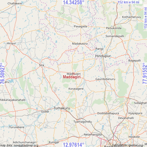
Maddagiri GPS coordinates[2]
13° 39' 37.26" North, 77° 12' 44.604" East
| Map corner | latitude | longitude |
|---|---|---|
| Upper-left | 14.34258°, | 76.50927° |
| Center: | 13.66035°, | 77.21239° |
| Lower-right: | 12.97614°, | 77.91552° |
| Map W x H: | 151.9×151.9 km | = 94.4×94.4mi |
| max Lat: | 34.9274° ⇑84% North |
| Maddagiri: | 13.66035° |
| min Lat: | ⇓16% South 8.09008° |
| min Long | Maddagiri | max Long |
| 68.82655° | 77.21239° | 96.81° |
| W 39.1%⇐ | ⇒60.9% E |
Elevation
Elevation of Maddagiri is 756 m = 2480 ft, and this is 460.4 m = 1510 ft above average elevation for this country.
| Max E: |
3681 m = 12077 ft | 6.9% |
| Maddagiri | 756 m 2480 ft | |
| Avg. | 295.6 m = 970 ft | |
Min E: |
1 m = 3 ft | 93.1% |
See also: India elevation on elevation.city.
Geographical zone
Maddagiri is located in North Torrid zone (between Equator and Tropic of Cancer). Distance of this Northern Tropic circle is 1087 km =675.4 mi to North.| Distance of | km | miles | from Maddagiri |
|---|---|---|---|
| North Pole | 8488.2 | 5274.3 | to North |
| Arctic Circle | 5882.3 | 3655.1 | to North |
| Tropic Cancer | 1087 | 675.4 | to North |
| Equator | 1518.9 | 943.8 | to South |


Nearby cities:
15 places around Maddagiri: (largest is in red/bold)
• Bāgepalli
64.6 km =40.1 mi,  77°
77°
• Chik Ballāpur
61.1 km =38 mi,  114°
114°
• Dod Ballāpur
53.8 km =33.4 mi,  139°
139°
• Goribidnūr
33.4 km =20.8 mi,  99°
99°
• Gubbi
48.6 km =30.2 mi,  217°
217°
• Gudibanda
53.1 km =33 mi,  88°
88°
• Hindupur
35.4 km =22 mi,  58°
58°
• Hosakote
68.6 km =42.6 mi,  356°
356°
• Kodigenahalli
20 km =12.4 mi,  70°
70°
• Koratagere
15.6 km =9.7 mi,  170°
170°
• Nelamangala
65.3 km =40.6 mi,  162°
162°
• Penukonda
62.5 km =38.8 mi,  41°
41°
• Pāvugada
49.4 km =30.7 mi,  8°
8°
• Sīra
34.5 km =21.4 mi,  285°
285°
• Tumkūr
37.4 km =23.2 mi,  198°
198°
Sources, notices
• [Note1] Compared only with cities in India existing in our database
• [Src1] Map data: © OpenStreetMap contributors (CC-BY-SA)
• [Src2] Other city data from geonames.org with taken over terms of usage.
• [Src3] Geographical zone / Annual Mean Temperature by Robert A. Rohde @ Wikipedia
