Bāgepalli geodata
Bāgepalli (Karnataka) is a populated place; located in India in Asia/Kolkata (GMT+5.5) time zone. With population of 24,031 people, there are 1772 cities with bigger population in this country. Compared to other cities in India, 83.7% of cities are located further ↑North; 53.6% of cities are located further →East and 92.7% of cities have lower elevation than Bāgepalli. Note1


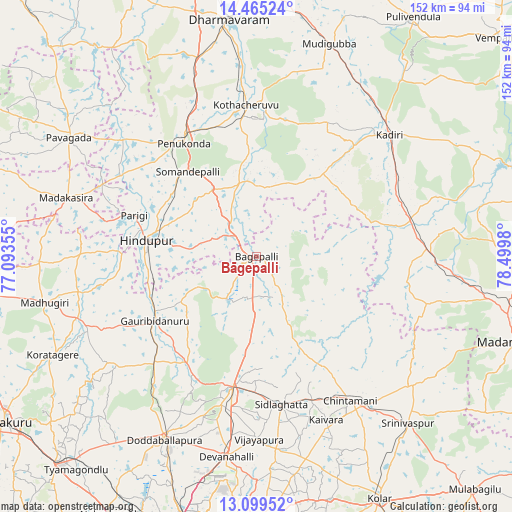
Bāgepalli GPS coordinates[2]
13° 47' 0.168" North, 77° 47' 48.012" East
| Map corner | latitude | longitude |
|---|---|---|
| Upper-left | 14.46524°, | 77.09355° |
| Center: | 13.78338°, | 77.79667° |
| Lower-right: | 13.09952°, | 78.4998° |
| Map W x H: | 151.9×151.9 km | = 94.4×94.4mi |
| max Lat: | 34.9274° ⇑83.7% North |
| Bāgepalli: | 13.78338° |
| min Lat: | ⇓16.3% South 8.09008° |
| min Long | Bāgepalli | max Long |
| 68.82655° | 77.79667° | 96.81° |
| W 46.4%⇐ | ⇒53.6% E |
Elevation
Elevation of Bāgepalli is 730 m = 2395 ft, and this is 434.4 m = 1425 ft above average elevation for this country.
| Max E: |
3681 m = 12077 ft | 7.3% |
| Bāgepalli | 730 m 2395 ft | |
| Avg. | 295.6 m = 970 ft | |
Min E: |
1 m = 3 ft | 92.7% |
See also: India elevation on elevation.city.
Geographical zone
Bāgepalli is located in North Torrid zone (between Equator and Tropic of Cancer). Distance of this Northern Tropic circle is 1073.4 km =667 mi to North.| Distance of | km | miles | from Bāgepalli |
|---|---|---|---|
| North Pole | 8474.5 | 5265.8 | to North |
| Arctic Circle | 5868.6 | 3646.6 | to North |
| Tropic Cancer | 1073.4 | 667 | to North |
| Equator | 1532.6 | 952.3 | to South |


Nearby cities:
15 places around Bāgepalli: (largest is in red/bold)
• Chik Ballāpur
39.4 km =24.5 mi,  190°
190°
• Chintāmani
50.7 km =31.5 mi,  147°
147°
• Devanhalli
60.4 km =37.5 mi, 188°
• Dod Ballāpur
61.1 km =38 mi,  207°
207°
• Gorantla
22.5 km =14 mi,  353°
353°
• Goribidnūr
35.8 km =22.2 mi,  237°
237°
• Gudibanda
16 km =9.9 mi,  218°
218°
• Hindupur
33.3 km =20.7 mi,  278°
278°
• Kadiri
53.6 km =33.3 mi,  47°
47°
• Kodigenahalli
44.9 km =27.9 mi,  261°
261°
• Maddagiri
64.6 km =40.1 mi, 257°
• Penukonda
39.8 km =24.7 mi,  326°
326°
• Puttaparthi
42.5 km =26.4 mi,  2°
2°
• Sidlaghatta
44.5 km =27.7 mi,  170°
170°
• Vadigenhalli
54.1 km =33.6 mi,  179°
179°
Sources, notices
• [Note1] Compared only with cities in India existing in our database
• [Src1] Map data: © OpenStreetMap contributors (CC-BY-SA)
• [Src2] Other city data from geonames.org with taken over terms of usage.
• [Src3] Geographical zone / Annual Mean Temperature by Robert A. Rohde @ Wikipedia
