Gorantla geodata
Gorantla (Andhra Pradesh) is a populated place; located in India in Asia/Kolkata (GMT+5.5) time zone. With population of 24,586 people, there are 1732 cities with bigger population in this country. Compared to other cities in India, 83.4% of cities are located further ↑North; 54.1% of cities are located further →East and 90.8% of cities have lower elevation than Gorantla. Note1


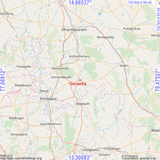
Gorantla GPS coordinates[2]
13° 59' 2.796" North, 77° 46' 20.064" East
| Map corner | latitude | longitude |
|---|---|---|
| Upper-left | 14.66537°, | 77.06912° |
| Center: | 13.98411°, | 77.77224° |
| Lower-right: | 13.30083°, | 78.47537° |
| Map W x H: | 151.7×151.7 km | = 94.3×94.3mi |
| max Lat: | 34.9274° ⇑83.4% North |
| Gorantla: | 13.98411° |
| min Lat: | ⇓16.6% South 8.09008° |
| min Long | Gorantla | max Long |
| 68.82655° | 77.77224° | 96.81° |
| W 45.9%⇐ | ⇒54.1% E |
Elevation
Elevation of Gorantla is 649 m = 2129 ft, and this is 353.4 m = 1159 ft above average elevation for this country.
| Max E: |
3681 m = 12077 ft | 9.2% |
| Gorantla | 649 m 2129 ft | |
| Avg. | 295.6 m = 970 ft | |
Min E: |
1 m = 3 ft | 90.8% |
See also: India elevation on elevation.city.
Geographical zone
Gorantla is located in North Torrid zone (between Equator and Tropic of Cancer). Distance of this Northern Tropic circle is 1051 km =653.1 mi to North.| Distance of | km | miles | from Gorantla |
|---|---|---|---|
| North Pole | 8452.2 | 5252 | to North |
| Arctic Circle | 5846.3 | 3632.7 | to North |
| Tropic Cancer | 1051 | 653.1 | to North |
| Equator | 1554.9 | 966.2 | to South |


Nearby cities:
15 places around Gorantla: (largest is in red/bold)
• Bāgepalli
22.5 km =14 mi,  173°
173°
• Chik Ballāpur
61.2 km =38 mi,  184°
184°
• Chintāmani
71.6 km =44.5 mi,  155°
155°
• Dharmavaram
48.2 km =30 mi,  353°
353°
• Goribidnūr
49.8 km =30.9 mi,  213°
213°
• Gudibanda
35.6 km =22.1 mi,  191°
191°
• Hindupur
34.9 km =21.7 mi,  240°
240°
• Kadiri
44.1 km =27.4 mi,  71°
71°
• Kodigenahalli
50.9 km =31.6 mi,  234°
234°
• Maddagiri
70.4 km =43.7 mi, 239°
• Penukonda
22.1 km =13.7 mi,  299°
299°
• Pulivendla
68.9 km =42.8 mi,  45°
45°
• Puttaparthi
20.6 km =12.8 mi,  11°
11°
• Pāvugada
54.6 km =33.9 mi,  283°
283°
• Sidlaghatta
66.9 km =41.6 mi, 171°
Sources, notices
• [Note1] Compared only with cities in India existing in our database
• [Src1] Map data: © OpenStreetMap contributors (CC-BY-SA)
• [Src2] Other city data from geonames.org with taken over terms of usage.
• [Src3] Geographical zone / Annual Mean Temperature by Robert A. Rohde @ Wikipedia
