Sidlaghatta geodata
Sidlaghatta (Karnataka) is a populated place; located in India in Asia/Kolkata (GMT+5.5) time zone. With population of 49,114 people, there are 900 cities with bigger population in this country. Compared to other cities in India, 84.6% of cities are located further ↑North; 52.9% of cities are located further →East and 95.3% of cities have lower elevation than Sidlaghatta. Note1


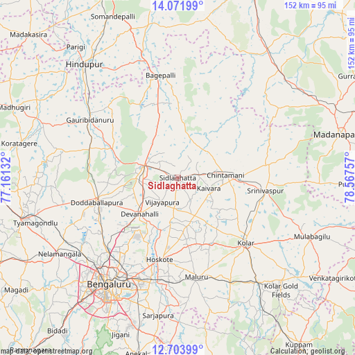
Sidlaghatta GPS coordinates[2]
13° 23' 20.256" North, 77° 51' 51.984" East
| Map corner | latitude | longitude |
|---|---|---|
| Upper-left | 14.07199°, | 77.16132° |
| Center: | 13.38896°, | 77.86444° |
| Lower-right: | 12.70399°, | 78.56757° |
| Map W x H: | 152.1×152.1 km | = 94.5×94.5mi |
| max Lat: | 34.9274° ⇑84.6% North |
| Sidlaghatta: | 13.38896° |
| min Lat: | ⇓15.4% South 8.09008° |
| min Long | Sidlaghatta | max Long |
| 68.82655° | 77.86444° | 96.81° |
| W 47.1%⇐ | ⇒52.9% E |
Elevation
Elevation of Sidlaghatta is 901 m = 2956 ft, and this is 605.4 m = 1986 ft above average elevation for this country.
| Max E: |
3681 m = 12077 ft | 4.7% |
| Sidlaghatta | 901 m 2956 ft | |
| Avg. | 295.6 m = 970 ft | |
Min E: |
1 m = 3 ft | 95.3% |
See also: Sidlaghatta elevation on elevation.city.
Geographical zone
Sidlaghatta is located in North Torrid zone (between Equator and Tropic of Cancer). Distance of this Northern Tropic circle is 1117.2 km =694.2 mi to North.| Distance of | km | miles | from Sidlaghatta |
|---|---|---|---|
| North Pole | 8518.3 | 5293 | to North |
| Arctic Circle | 5912.5 | 3673.9 | to North |
| Tropic Cancer | 1117.2 | 694.2 | to North |
| Equator | 1488.7 | 925 | to South |


Nearby cities:
15 places around Sidlaghatta: (largest is in red/bold)
• Bengaluru
54.9 km =34.1 mi,  212°
212°
• Bāgepalli
44.5 km =27.7 mi,  350°
350°
• Chik Ballāpur
15.6 km =9.7 mi,  289°
289°
• Chintāmani
20.3 km =12.6 mi,  86°
86°
• Dasarahalli
32.4 km =20.1 mi,  186°
186°
• Devanhalli
22.9 km =14.2 mi,  226°
226°
• Dod Ballāpur
36.9 km =22.9 mi,  253°
253°
• Goribidnūr
44.9 km =27.9 mi,  303°
303°
• Gudibanda
35.8 km =22.2 mi,  331°
331°
• Hoskote
36.1 km =22.4 mi, 191°
• Kolār
40.1 km =24.9 mi,  134°
134°
• Mālūr
43.6 km =27.1 mi,  169°
169°
• Srīnivāspur
38 km =23.6 mi,  98°
98°
• Vadigenhalli
12.2 km =7.6 mi, 213°
• Yelahanka
43.2 km =26.8 mi,  222°
222°
Sources, notices
• [Note1] Compared only with cities in India existing in our database
• [Src1] Map data: © OpenStreetMap contributors (CC-BY-SA)
• [Src2] Other city data from geonames.org with taken over terms of usage.
• [Src3] Geographical zone / Annual Mean Temperature by Robert A. Rohde @ Wikipedia
