Fīrozpur Jhirka geodata
Fīrozpur Jhirka (Haryana) is a populated place; located in India in Asia/Kolkata (GMT+5.5) time zone. With population of 20,195 people, there are 2024 cities with bigger population in this country. Compared to other cities in India, 83.4% of cities are located further ↓South; 63.8% of cities are located further →East and 52.8% of cities have lower elevation than Fīrozpur Jhirka. Note1


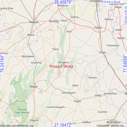
Fīrozpur Jhirka GPS coordinates[2]
27° 47' 18.708" North, 76° 56' 41.856" East
| Map corner | latitude | longitude |
|---|---|---|
| Upper-left | 28.40878°, | 76.24184° |
| Center: | 27.78853°, | 76.94496° |
| Lower-right: | 27.16472°, | 77.64809° |
| Map W x H: | 138.3×138.3 km | = 85.9×85.9mi |
| max Lat: | 34.9274° ⇑16.6% North |
| Fīrozpur Jhirka: | 27.78853° |
| min Lat: | ⇓83.4% South 8.09008° |
| min Long | Fīrozpur Jhirk | max Long |
| 68.82655° | 76.94496° | 96.81° |
| W 36.2%⇐ | ⇒63.8% E |
Elevation
Elevation of Fīrozpur Jhirka is 217 m = 712 ft, and this is 78.6 m = 258 ft below average elevation for this country.
| Max E: |
3681 m = 12077 ft | 47.2% |
| Avg. | 295.6 m = 970 ft | |
| Fīrozpur Jhirka | 217 m = 712 ft | |
Min E: |
1 m = 3 ft | 52.8% |
See also: India elevation on elevation.city.
Geographical zone
Fīrozpur Jhirka is located in North temperate zone (between Tropic of Cancer and the Arctic Circle). Distance of this Northern Tropic circle is 483.9 km =300.7 mi to South.| Distance of | km | miles | from Fīrozpur Jhirka |
|---|---|---|---|
| North Pole | 6917.3 | 4298.2 | to North |
| Arctic Circle | 4311.4 | 2679 | to North |
| Tropic Cancer | 483.9 | 300.7 | to South |
| Equator | 3089.8 | 1919.9 | to South |


Nearby cities:
15 places around Fīrozpur Jhirka: (largest is in red/bold)
• Alwar
40.3 km =25 mi,  231°
231°
• Barsāna
45.2 km =28.1 mi,  110°
110°
• Bhiwadi
47.6 km =29.6 mi,  349°
349°
• Bāwal
47.5 km =29.5 mi,  311°
311°
• Govindgarh
32.1 km =19.9 mi,  170°
170°
• Hodal
43.1 km =26.8 mi,  74°
74°
• Kishangarh
21.4 km =13.3 mi,  279°
279°
• Kāman
35.1 km =21.8 mi, 114°
• Mandāwar
39.7 km =24.7 mi, 282°
• Nagar
43.3 km =26.9 mi,  159°
159°
• Nandgaon
44.3 km =27.5 mi,  101°
101°
• Nūh
35.4 km =22 mi,  9°
9°
• Pūnāhāna
26.8 km =16.7 mi, 71°
• Tijāra
18.4 km =11.4 mi,  331°
331°
• Tāoru
47.1 km =29.3 mi,  0°
0°
Sources, notices
• [Note1] Compared only with cities in India existing in our database
• [Src1] Map data: © OpenStreetMap contributors (CC-BY-SA)
• [Src2] Other city data from geonames.org with taken over terms of usage.
• [Src3] Geographical zone / Annual Mean Temperature by Robert A. Rohde @ Wikipedia
