Tāoru geodata
Tāoru (Haryana) is a populated place; located in India in Asia/Kolkata (GMT+5.5) time zone. With population of 19,310 people, there are 2097 cities with bigger population in this country. Compared to other cities in India, 85.5% of cities are located further ↓South; 63.7% of cities are located further →East and 62.8% of cities have lower elevation than Tāoru. Note1


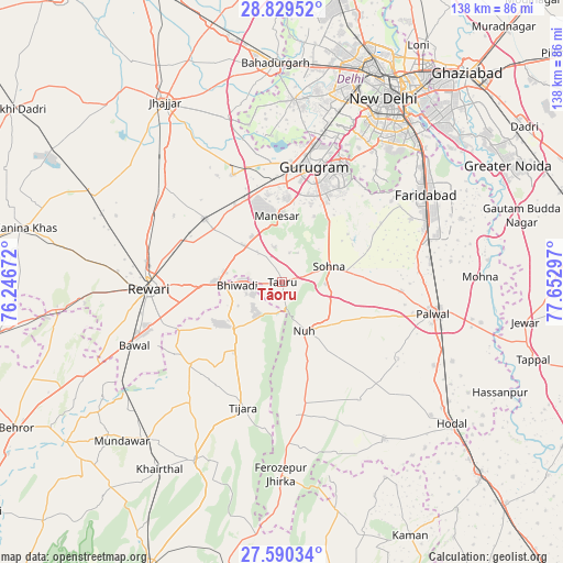
Tāoru GPS coordinates[2]
28° 12' 42.228" North, 76° 56' 59.424" East
| Map corner | latitude | longitude |
|---|---|---|
| Upper-left | 28.82952°, | 76.24672° |
| Center: | 28.21173°, | 76.94984° |
| Lower-right: | 27.59034°, | 77.65297° |
| Map W x H: | 137.8×137.8 km | = 85.6×85.6mi |
| max Lat: | 34.9274° ⇑14.5% North |
| Tāoru: | 28.21173° |
| min Lat: | ⇓85.5% South 8.09008° |
| min Long | Tāoru | max Long |
| 68.82655° | 76.94984° | 96.81° |
| W 36.3%⇐ | ⇒63.7% E |
Elevation
Elevation of Tāoru is 270 m = 886 ft, and this is 25.6 m = 84 ft below average elevation for this country.
| Max E: |
3681 m = 12077 ft | 37.2% |
| Avg. | 295.6 m = 970 ft | |
| Tāoru | 270 m = 886 ft | |
Min E: |
1 m = 3 ft | 62.8% |
See also: India elevation on elevation.city.
Geographical zone
Tāoru is located in North temperate zone (between Tropic of Cancer and the Arctic Circle). Distance of this Northern Tropic circle is 530.9 km =329.9 mi to South.| Distance of | km | miles | from Tāoru |
|---|---|---|---|
| North Pole | 6870.2 | 4268.9 | to North |
| Arctic Circle | 4264.3 | 2649.7 | to North |
| Tropic Cancer | 530.9 | 329.9 | to South |
| Equator | 3136.9 | 1949.2 | to South |


Nearby cities:
15 places around Tāoru: (largest is in red/bold)
• Bhiwadi
8.7 km =5.4 mi,  268°
268°
• Bāwal
39.2 km =24.4 mi,  246°
246°
• Deoli
42.5 km =26.4 mi,  40°
40°
• Dhāruhera
15 km =9.3 mi, 267°
• Faridabad
41.9 km =26 mi,  58°
58°
• Farrukhnagar
29 km =18 mi,  334°
334°
• Gurgaon
28.6 km =17.8 mi,  15°
15°
• Najafgarh
44.3 km =27.5 mi,  3°
3°
• Nūh
13.1 km =8.1 mi,  157°
157°
• Palwal
37.6 km =23.4 mi,  101°
101°
• Pataudi
21 km =13 mi,  307°
307°
• Pūnāhāna
46.1 km =28.6 mi,  147°
147°
• Rewāri
32.5 km =20.2 mi, 267°
• Sohna
12 km =7.5 mi,  70°
70°
• Tijāra
32.2 km =20 mi,  196°
196°
Sources, notices
• [Note1] Compared only with cities in India existing in our database
• [Src1] Map data: © OpenStreetMap contributors (CC-BY-SA)
• [Src2] Other city data from geonames.org with taken over terms of usage.
• [Src3] Geographical zone / Annual Mean Temperature by Robert A. Rohde @ Wikipedia
