Nagar geodata
Nagar (Rajasthan) is a populated place; located in India in Asia/Kolkata (GMT+5.5) time zone. With population of 23,546 people, there are 1794 cities with bigger population in this country. Compared to other cities in India, 81.3% of cities are located further ↓South; 62.1% of cities are located further →East and 50.3% of cities have lower elevation than Nagar. Note1


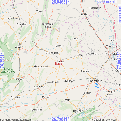
Nagar GPS coordinates[2]
27° 25' 26.292" North, 77° 5' 57.192" East
| Map corner | latitude | longitude |
|---|---|---|
| Upper-left | 28.04631°, | 76.3961° |
| Center: | 27.42397°, | 77.09922° |
| Lower-right: | 26.79811°, | 77.80235° |
| Map W x H: | 138.8×138.8 km | = 86.2×86.2mi |
| max Lat: | 34.9274° ⇑18.7% North |
| Nagar: | 27.42397° |
| min Lat: | ⇓81.3% South 8.09008° |
| min Long | Nagar | max Long |
| 68.82655° | 77.09922° | 96.81° |
| W 37.9%⇐ | ⇒62.1% E |
Elevation
Elevation of Nagar is 203 m = 666 ft, and this is 92.6 m = 304 ft below average elevation for this country.
| Max E: |
3681 m = 12077 ft | 49.7% |
| Avg. | 295.6 m = 970 ft | |
| Nagar | 203 m = 666 ft | |
Min E: |
1 m = 3 ft | 50.3% |
See also: India elevation on elevation.city.
Geographical zone
Nagar is located in North temperate zone (between Tropic of Cancer and the Arctic Circle). Distance of this Northern Tropic circle is 443.3 km =275.5 mi to South.| Distance of | km | miles | from Nagar |
|---|---|---|---|
| North Pole | 6957.8 | 4323.4 | to North |
| Arctic Circle | 4351.9 | 2704.1 | to North |
| Tropic Cancer | 443.3 | 275.5 | to South |
| Equator | 3049.3 | 1894.7 | to South |


Nearby cities:
15 places around Nagar: (largest is in red/bold)
• Alwar
49.2 km =30.6 mi,  288°
288°
• Barsāna
37 km =23 mi,  47°
47°
• Bharatpur
44.9 km =27.9 mi,  120°
120°
• Bhasāwar
43.1 km =26.8 mi,  186°
186°
• Dīg
23 km =14.3 mi,  76°
76°
• Fīrozpur Jhirka
43.3 km =26.9 mi,  339°
339°
• Govardhan
36.8 km =22.9 mi, 77°
• Govindgarh
13.3 km =8.3 mi,  312°
312°
• Kāman
30.9 km =19.2 mi,  32°
32°
• Kūmher
29.4 km =18.3 mi,  114°
114°
• Mahwah
45.2 km =28.1 mi,  201°
201°
• Nandgaon
42.7 km =26.5 mi,  41°
41°
• Nādbai
24.3 km =15.1 mi,  156°
156°
• Rādhākund
40.2 km =25 mi,  73°
73°
• Wer
45.7 km =28.4 mi,  170°
170°
Sources, notices
• [Note1] Compared only with cities in India existing in our database
• [Src1] Map data: © OpenStreetMap contributors (CC-BY-SA)
• [Src2] Other city data from geonames.org with taken over terms of usage.
• [Src3] Geographical zone / Annual Mean Temperature by Robert A. Rohde @ Wikipedia
